Geography and Geology of the Pacific
A DigitalNZ Story by National Library Services to Schools
This story looks at the geography and geology of the Pacific and its many islands.
BACKGROUND
The Pacific is an extraordinary part of the world, encompassing the Pacific Ocean, and a scattering of islands and atolls on which resilient groups of people have not only existed but developed dynamic cultures. It is a volatile region prone to earthquakes, volcanic eruptions and tsunami, and is also home to flora and fauna that have adapted to suit often harsh conditions.
Mostly below the Equator, there are more than 25,000 islands in the Pacific region. This story looks at the geography and geology of these landforms as well as the ocean they are part of.
CONTENTS
- The Pacific Ocean
- Hurricanes
- Tectonic Plates - The Ring of Fire
- Ocean trenches
- Coral reefs
- High islands
- Low islands & atolls
- Glossary
- Supporting resources.
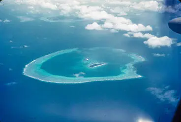
A Pacific atoll from the air.
Manatū Taonga, the Ministry for Culture and Heritage
THE PACIFIC OCEAN
The Pacific Ocean is the largest and deepest body of water on Earth, with an area of approximately 165.25 million square km. It covers around one-third of the planet's surface and is double the area of the Atlantic Ocean.
The Pacific stretches from the Arctic in the north, Antarctica in the south, Australia and Asia to the west, and North and South America to the east. It contains over half the free water on our planet.
The Pacific Ocean from space.
Manatū Taonga, the Ministry for Culture and Heritage
QUICK FACTS
- The Pacific Ocean originated when Earth's Proterozoic continent split in two.
- Rocks found here are the oldest on the planet and were formed around 200 million years ago.
- Although the sea tastes very salty, salt only comprises approximately 3.5% of the water, that also contains over 86 different elements, including precious metals such as gold.
- The Pacific has many currents, both surface and deep. Deep currents are created by the sun's heat, which causes the warmed water to flow towards the poles where it sinks as it cools and then flows back towards warmer zones.
- The ocean is split into five zones, each providing habitat for different sea life that have adapted to survive there; Sunlit zone (to 200m), Twilight zone (to 1,000m), Dark zone (to 4,000m), Abyssal zone (to 6,000m) and the Hadal zone (in ocean trenches). Only two people have ever visited the Hadal zone.
- Half of the world's species live in our oceans, and most of the world's supply of fish is caught in the Pacific Ocean.
- Storms of all kinds are created in part by warm oceans and the Pacific is responsible for some of the most devastating hurricanes ever seen.
The Pacific.
National Library of New Zealand
Great ocean conveyor belt
Manatū Taonga, the Ministry for Culture and Heritage
Zones of the ocean
Manatū Taonga, the Ministry for Culture and Heritage
HURRICANES
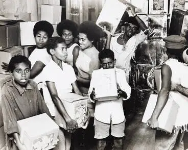
Hurricanes, one of the most destructive natural events on our planet, form over the Pacific Ocean. Hurricanes, cyclones and typhoons are the same thing but are given different names depending on their location.
Hurricanes are a combination of heat (from the sun), wind and water. In order for hurricanes to develop, an atmospheric event such as a thunderstorm needs to happen over warm ocean water causing moisture to rise. When several of these thunderstorms merge together, low pressure is created underneath and the clouds begin to rotate. The speed of the rotation increases and spreads the clouds outwards, creating a hurricane.
QUICK FACTS
- The 'eye of the storm' is a calm area with no clouds in the centre of a hurricane.
- The approach of a hurricane can be measured with a barometer, a sophisticated piece of equipment that uses mercury to gauge the level of atmospheric pressure - the lower the pressure, the stronger the hurricane.
- Hurricanes cause so much damage because of the extremely high winds, torrential rain and enormous waves they cause.
- When hurricanes reach large landmasses, they lose the heat they gathered from the ocean, and quickly disappear.
- Scientists believe that climate change will cause more hurricanes in the future as the water of the Pacific Ocean continues to warm.
Vao
Auckland War Memorial Museum Tāmaki Paenga Hira
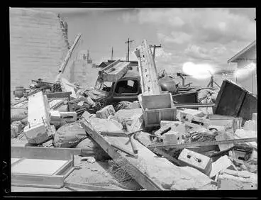
Relief supplies, Fiji, 1972
Auckland Libraries
TECTONIC PLATES - THE RING OF FIRE
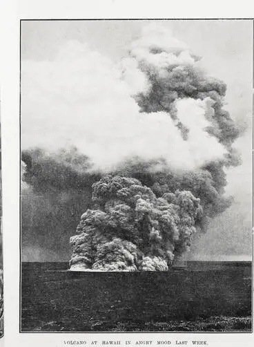
The Earth's surface is fractured into several different sections called tectonic plates. These plates are slowly but continually moving, sliding apart and past each other, as well as under and over. As this happens, earthquakes, and sometimes tsunami, occur. Volcanoes can also erupt as a result of this movement as gaps in the Earth's crust allow molten magma to escape to the surface.
In the Pacific, the Pacific and American plates, as well as the Pacific and Australian plates are moving against each other. The areas where this is occurring forms a ring around the edge of the Pacific Ocean that is so prone to volcanoes it has been dubbed the Ring of Fire.
QUICK FACTS
- 75% of all active volcanoes on Earth are part of the Ring of Fire, and roughly 90% of all earthquakes occur here.
- The Pacific Plate varies in age, the oldest parts are estimated at 100 million years old and the youngest 2 million years.
- Historic volcanic activity across Asia has resulted in very fertile soils, and as a result, millions of people now live in these areas which are in constant danger from earthquakes and volcanoes.
- Hawaii currently has 5 active volcanoes. Mount Fuji and Sakurajima are two of the most active volcanoes in Japan, a country with more than a hundred active volcanoes.
- The volcano Popocatepetl in Mexico has erupted repeatedly since 1994, threatening the 26,500,000 people who live in Mexico City.
- Volcanoes in the American continent have been less active than Asia, however, Mount St Helens erupted in 1980 killing 57 people and causing wide devastation.
Continental and oceanic crust
Manatū Taonga, the Ministry for Culture and Heritage
Theodolite
Museum of New Zealand Te Papa Tongarewa
Antarctica tectonic plates
Antarctica New Zealand
OCEAN TRENCHES
The deepest parts of the ocean are often where two or more plates meet and are called trenches. The deepest of these form part of the Ring of Fire. Because of the depth of trenches, they are completely dark and extremely cold, and this creates very unique environments.
The trenches in the Pacific Ocean are the:
- Mariana - 10.99 km deep
- Tonga - 10.882 km deep
- Philippine - 10.54 km deep
- Kuril- Kamchatka - 10.5 km deep
- Kermadec - 10.4 km deep
- Izu-Ogasawara - 9.78 km deep
- Japan - 9 km deep
- Puerto Rico - 8.64 km deep
- South Sandwich - 8.42 km deep
- Peru-Chile - 8.06 km deep
Map showing the meeting of plates under New Zealand, and the start of the Kermadec Trench.
Manatū Taonga, the Ministry for Culture and Heritage
QUICK FACTS
- Oceanographers are scientist that explore the geography of the world's oceans. Until the 1950s, it was thought that there was little or no life in trenches, but since then many extraordinary creatures have been discovered, such as anglerfish.
- Ocean trenches or canyons were originally called 'deeps'.
- At its deepest, the Mariana trench is 10,994 m deep - Mt Everest could fit in the trench with 2 km to spare!
- The pressure at this depth of the ocean is immense, more than 1,000 times greater than on Earth, at approximately 12,400 tons per square metre.
- The temperature in deep trenches is just above freezing point.
Puysegur Trench
Manatū Taonga, the Ministry for Culture and Heritage
Humpback anglerfish, Melanocetus johnsonii Gunther, 1864
Museum of New Zealand Te Papa Tongarewa
Graveyard seamounts, Chatham Rise
Manatū Taonga, the Ministry for Culture and Heritage
CORAL REEFS
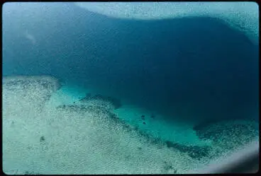
Barrier reefs are the most common type of coral reef and are separated from the land by lagoons. The three other types of reef are fringing reefs, that extend out from the land into the ocean, atolls, which form as a ring around an underwater volcano, and lastly platform reefs, that form on top of mountains or ridges on the ocean floor.
The Pacific is full of coral reefs of all types, shapes and sizes. These habitats sustain not only flora and fauna, but the people who live on the islands who depend on the food that these reefs support.
The largest living structure on Earth.
Museum of New Zealand Te Papa Tongarewa
QUICK FACTS
- The Pacific Ocean's largest reef is the Great Barrier Reef off the eastern coast of Australia. It is the largest living structure on Earth at more than 2,000 km in length.
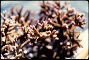
- Coral are living creatures that grow incredibly slowly, extracting calcium carbonate from the water to create hard protective structures around themselves.
- On a healthy coral reef, there can be up to 100 different kinds of coral crammed into space the size of a soccer pitch.
- Coral can be ancient; geologists have recently found evidence of corals that are half a million years old.
- Delicate and diverse, reefs are one of the most fragile ecosystems on our planet.
Aerial view of coral reef, 1971
Auckland Libraries
Coral, 1971
Auckland Libraries
HIGH ISLANDS
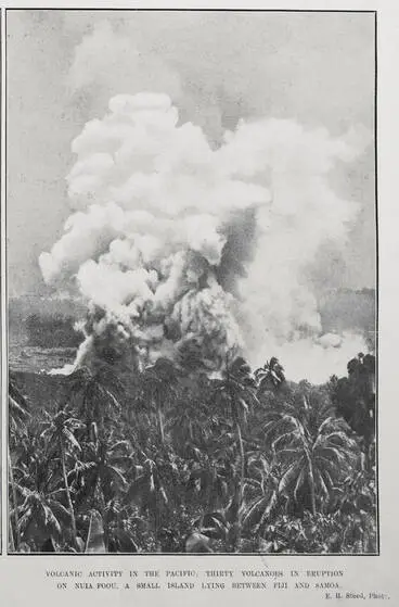
Also known as volcanic islands and oceanic islands, high islands are the result of successive volcanic eruptions on the sea floor that build up over time to create land. These islands can be recognised by their often conical shape, and in time, they can rise high above sea level.
Melanesia has many examples of high islands as a result of sitting on part of the Ring of Fire where the Pacific and Australian plates meet.
QUICK FACTS
- Prominent high islands in the Pacific include the Hawaiin group of islands, Mount Tomanivi in Fiji, Mount Lamington in Papua New Guinea, and Mount Yasur in Vanuatu.
- When high islands are in the process of forming below sea level they are called seamounts.
- High islands can range in size from 1 square kilometre to much larger and account for around 39% of the islands in the Pacific.
- Igneous or calcareous rocks make up approximately 80% of the composition of high islands.
- When molten magma from the Earth's interior erupts from a volcano it is called lava if it flows, and tephra if it flies into the air.
- Lava or tephra contains nearly all of Earth's known chemical elements, explaining why soils near volcanoes eventually become rich and fertile.
Volcanic activity in the pacific
Auckland Libraries
Volcano, Tanna, Vanuatu
Museum of New Zealand Te Papa Tongarewa
LOW ISLANDS AND ATOLLS
Low islands are also known as coral islands because they are made up of millions of living coral and their skeletons. Often, these islands are just above sea level and surrounded by lagoons.
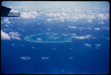
When a number of small low islands form a ring shape with a lagoon in the centre, this is called an atoll. Atolls are created when coral reefs form around volcanic islands, and the island erodes away over time, leaving a lagoon in its place.
The low lying islands of Tokelau.
Museum of New Zealand Te Papa Tongarewa
QUICK FACTS
- The Pacific has many low islands and atolls, including the Kwajalein Atoll in the Marshall Islands, that has a lagoon with an area of 2,173 square kilometers.
- The nation of Kiribati is made up of one island and 32 atolls spread over a wide area of the Pacific.
- Coral atolls, like the islands of Tokelau, have no surface water so people who live there have to dig down into the sand to access freshwater.
- Many low islands are just a few meters above sea level and as a result, are severely affected by the rise in sea levels resulting from climate change.
- People living on low Islands and atolls are also very vulnerable to cyclones and tsunami as there is no high land to escape to in the event of an emergency.
[Aerial view of two atolls]
Auckland War Memorial Museum Tāmaki Paenga Hira
Rakahanga, Cook Islands, 1:25 000.
National Library of New Zealand
GLOSSARY
Definitions below taken from the Oxford Learner's Dictionary.
atmospheric- related to the earth’s atmosphere.
calcareous - of the nature of (carbonate of) lime; composed of or containing lime or lime-stone.
ecosystem -all the plants and living creatures in a particular area considered in relation to their physical environment.
elements- a simple chemical substance that consists of atoms of only one type and cannot be split by chemical means into a simpler substance. Gold, oxygen and carbon are all elements.
equator- an imaginary line around the earth at an equal distance from the North and South Poles.
extracting- to remove or obtain a substance from something, for example by using an industrial or a chemical process.
fauna- all the animals living in an area or in a particular period of history.
flora- the plants of a particular area, type of environment or period of time.
geologist - a scientist who studies geology.
igneous- formed when magma (= melted or liquid material lying below the earth’s surface) becomes solid, especially after it has poured out of a volcano.
molten-(of metal, rock or glass) heated to a very high temperature so that it becomes liquid.
magma- very hot liquid rock found below the earth’s surface.
tsunami - an extremely large wave in the sea caused, for example, by an earthquake.
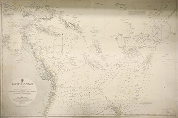
A map of the Pacific from around 1908.
Auckland War Memorial Museum Tāmaki Paenga Hira
SUPPORTING RESOURCES
Active volcanoes of Hawaii — the Hawaiian Islands are at the southeast end of a chain of volcanoes that began to form more than 70 million years ago.
An ocean of islands — scattered across the Pacific are many different kinds of islands, formed in different ways, and offering different resources to the people who live there.
Atoll — an atoll is a ring-shaped coral reef, island, or series of islets. The atoll surrounds a body of water called a lagoon.
Australia and Oceania: Physical geography - Oceania is a region made up of thousands of islands throughout the South Pacific Ocean.
Cyclones, typhoons and hurricanes - the terms cyclone, hurricane and typhoon refer to what scientists call a tropical cyclone. The terms differ depending upon where they occur.
Earth's shifting tectonic plates - a gallery of map illustrations showing the positions of tectonic plates in the geologic past.
Earth's tropical islands (requires login) — Hawaii is the most remote island chain on Earth, and its tropical shores are hard to reach. From newly formed lava fields, to lush jungles, and vibrant coral reefs, these diverse and beautiful islands have it all.
Eastern Pacific records its most energetic hurricane season — scientists suspect this may be a symptom of climate change — and more scary storms to come.
Fiji's Cyclone Winston damage: Before and after — the first satellite photos of cyclone-hit Fiji reveal the scale of the damage, and the huge rebuilding task ahead across many remote islands.
Half of the Great Barrier Reef is dead — see where coral in the world's largest coral reef system has been bleached to death.
Hurricanes, cyclones and typhoons — tropical cyclones in the Atlantic Ocean or Eastern Pacific are known as hurricanes.
Island — there are countless islands in the ocean, lakes, and rivers around the world. They vary greatly in size, climate, and the kinds of organisms that inhabit them.
Lagoons — a lagoon is a shallow body of water that may have an opening to a larger body of water, but is also protected from it by a sandbar or coral reef.
Marine ecosystems — marine ecosystems contain a diverse array of living organisms and abiotic processes.
Ocean trench — ocean trenches are long, narrow depressions on the seafloor.
Pacific Ocean — of the three oceans that extend northward from the Antarctic continent, the Pacific is by far the largest.
Plate tectonics — since the 1950s, several discoveries have led to a new understanding of how the Earth works.
Plate tectonics and the Ring of Fire — the Ring of Fire is a string of volcanoes and sites of seismic activity, or earthquakes, around the edges of the Pacific Ocean.
Rising seas give island nation a stark choice: relocate or elevate — climate change means the low-lying Marshall Islands must consider drastic measures, including building new artificial islands.
Samoa: a group of high volcanic islands — a high volcanic island is rugged and mountainous – formed by volcanic activity.
Seafloor spreading — seafloor spreading is a geologic process in which tectonic plates—large slabs of Earth's lithosphere—split apart from each other.
Sea level rise worse in Pacific than other regions — the sea level is rising more in the South Pacific than in other regions, the author of a new book about the impact of climate change on coastlines says.
Structure of volcanoes — spectacular eruptions from volcanoes have fascinated humans ever since people first walked on the Earth.
Tectonic Plates - this animated video shows the movement of the tectonic plates that make up the Earth’s crust.
The cracks ripping Earth apart — all the physical movements in nature we see on Earth's surface are extremely feeble compared to what is happening deep underground.
The moving Earth - the huge tectonic plates that cover the Earth fit together a bit like pieces in a global puzzle.
The Great Barrier Reef — the largest living structure on Earth.
The Pacific's fiery ring — deep within the Earth, rocky plates compress and pull apart, triggering huge quakes and eruptions—and threatening millions.
The Pacific Ocean explained — the largest ocean on Earth is filled with mysteries, but also subject to great pressures like climate change, plastic pollution, and overfishing.
The Pacific or "Peaceful" Ocean — the Pacific Ocean gained its name in the 16th century from the Portuguese navigator Ferdinand Magellan.
Tokelau: three low coral atolls — this land consists of sand and coral that has built up on the surface of the reef.
Tsunami — tsunami are waves caused by sudden movement of the ocean surface due to earthquakes, landslides on the sea floor, land slumping into the ocean, large volcanic eruptions or meteorite impact in the ocean.
Types of volcanic rock — rocks are not all the same. Some are heavy, some are light. Others are dark, while some can be almost pure white.
Undersea geology — students locate and label geologic features of the ocean and explore the relationship of these features to plate tectonics.
Vast 'pumice raft' found drifting through Pacific Ocean — a vast "raft" of volcanic rocks stretching over 150 sq km (58 sq miles) is drifting through the Pacific Ocean, scientists say.
Volcano — a selection of videos from Encyclopeadia Britannica about volcanoes
Volcanoes — a volcano is a landform that results from magma (molten rock within the earth) erupting at the surface.
What are coral reefs — appearing as solitary forms in the fossil record more than 400 million years ago, corals are extremely ancient animals that evolved into modern reef-building forms over the last 25 million years.
This story was curated and compiled by Te Puna Mātauranga o Aotearoa | National Library of New Zealand, Services to Schools staff, April 2020.




![[Aerial view of two atolls] Image: [Aerial view of two atolls]](https://thumbnailer.digitalnz.org/?resize=770x&src=https%3A%2F%2Fcollection-api.aucklandmuseum.com%2Frecords%2Fimages%2Fmedium%2F533275%2Fc1117744add527ac5004956f2c5f1439d0a5b253.jpg&resize=368%253E)
