Quiz time: NZ geography

A DigitalNZ Story by Zokoroa

Here are some quiz questions and answers on NZ geography for you to test yourself!

Geography, Place names, Mountains, Rivers, Quiz

Test yourself on the following ten questions. The answers are given below, together with links to further information about each place name.

1.  What is the name of NZ's highest mountain?

Image: Mount Taranaki

Mount Taranaki / Egmont

Mount Taranaki

Alexander Turnbull Library

Image: Mt Cook

Mount Cook / Aoraki

Mt Cook

Manatū Taonga, the Ministry for Culture and Heritage

Image: Southern Alps, Mount Aspiring

Mount Aspiring / Tititea

Southern Alps, Mount Aspiring

Museum of New Zealand Te Papa Tongarewa

2. What is our longest river?

Image: Clutha River Bridge, Cromwell, Central Otago

Clutha River

Clutha River Bridge, Cromwell, Central Otago

Manatū Taonga, the Ministry for Culture and Heritage

Image: Wanganui River

Whanganui River

Wanganui River

Museum of New Zealand Te Papa Tongarewa

Image: Waikato

Waikato River

Waikato

Manatū Taonga, the Ministry for Culture and Heritage

3. What is our highest waterfall (either water free-falling in mid-air or cascading down      rocks)? 

Image: Fiordland, Sutherland Falls

Sutherland Falls in Fiordland

Fiordland, Sutherland Falls

Museum of New Zealand Te Papa Tongarewa

Image: Browne Falls

Browne Falls in Doubtful Sound

Browne Falls

Manatū Taonga, the Ministry for Culture and Heritage

Image: Bridal Veil Falls

Bridal Veil Falls, Raglan

Bridal Veil Falls

Manatū Taonga, the Ministry for Culture and Heritage

4. What is the name of our largest active geyser?

Image: Prince of Wales' Feathers geyser, Wairakei

Prince of Wales' Feathers Geyser at Wairakei near Taupō

Prince of Wales' Feathers geyser, Wairakei

Alexander Turnbull Library

Image: Lady Knox geyser erupting

Lady Knox Geyser in Waiotapu area south of Rotorua

Lady Knox geyser erupting

Manatū Taonga, the Ministry for Culture and Heritage

Image: Pohutu Geyser, Rotorua, includes unidentified tourists and thermal area

Pōhutu Geyser at Whakarewarewa in Rotorua

Pohutu Geyser, Rotorua, includes unidentified tourists and thermal area

Alexander Turnbull Library

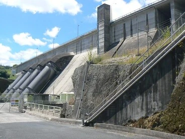
5. How many dams were built along the Waikato River & can you name any of them?

Image: P1250412

P1250412

Manatū Taonga, the Ministry for Culture and Heritage
6. What is NZ's second largest lake in surface area? (Lake Taupō is the largest)

Image: Queenstown

Lake Whakatipu

Queenstown

Manatū Taonga, the Ministry for Culture and Heritage

Image: Lake Te Anau, 1974

Lake Te Anau

Lake Te Anau, 1974

Auckland Libraries

Image: lake wanaka

Lake Wanaka

lake wanaka

Manatū Taonga, the Ministry for Culture and Heritage

7.  What is the name of the body of water separating Stewart Island from the South      Island?

Image: Ferry in Cook Strait, 1967

Cook Strait

Ferry in Cook Strait, 1967

Auckland Libraries

Image: Tory Channel Heads

Tory Channel

Tory Channel Heads

Manatū Taonga, the Ministry for Culture and Heritage

8. Where is Farewell Spit located?

Image: Te Ika a Maui - the North Island

North Island

Te Ika a Maui - the North Island

Aotearoa People's Network Kaharoa

Image: Te Wai Pounamu - the South Island

South Island

Te Wai Pounamu - the South Island

Aotearoa People's Network Kaharoa

Image: Stewart Island [electronic resource].

Stewart Island

Stewart Island [electronic resource].

National Library of New Zealand

9. On which coast are the Moeraki Boulders?

Image: EastCapeTrip 581b

East Coast at Tolaga Bay north of Gisborne

EastCapeTrip 581b

Manatū Taonga, the Ministry for Culture and Heritage

Image: The Bluff, Ninety Mile Beach

Northland Coast at Ninety Mile Beach near Bluff

The Bluff, Ninety Mile Beach

Auckland Libraries

Image: Fog, Otago coast

Otago Coast at Koekohe Beach near Hampden

Fog, Otago coast

Manatū Taonga, the Ministry for Culture and Heritage

10. Name the island in Lake Rotorua where Hinemoa met up with Tūtānekai 

Image: Lake Rotorua

Lake Rotorua

Manatū Taonga, the Ministry for Culture and Heritage

Answers:

1.    Mount Cook / Aoraki: 3,724 metres high (Te Ara: Mountains)

2.   Waikato River: 425 kilometres (Te Ara: New Zealand’s longest rivers)

3.   Browne Falls: 836 metres (Te Ara: Waterfalls)

4.   Pōhutu reaches 15-20+ metres height (Te Ara: Geysers)

5.   Eight dams: Aratiatia, Ohakuri, Atiamuri, Whakamaru, Maraetai, Waipapa, Arapuni, and Karapiro         (NZPlaces: Waikato hydro day out)

6.   Lake Te Anau (348 square kms) (Te Ara: Lakes)

7.    Fouveaux Strait (Te Ara: Stewart Island/Rakiura)

8.   South Island (near northernmost point) (Te Ara: Nelson places)

9.   Otago Coast at Moeraki Beach (Te Ara: Otago places)

10.  Mokoia Island (Te Ara: Roadside Stories: Island romance in Lake Rotorua)

FURTHER NZ QUIZZES: