1931 Napier
A DigitalNZ Story by Duncan Roper
The 1931 Earthquake shook Hawke’s Bay on the Third of February at 10:47 am. It killed more than 256 people. It leads to the complete destruction of many major landmarks and many buildings in the area.
Destruction in Napier
At 10.47am on 3 February 1931, a violent shock, followed closely by a second, rocked Hawke’s Bay for almost three minutes. A tanker at sea felt a violent vibration, and the seamen on board looked to the shore to see Napier covered by a cloud of rising dust. The earthquake was felt in most of New Zealand, apart from the Auckland peninsula and Otago. The hands of the clock on the band rotunda in Napier stopped at the time the earthquake struck, 10:47 am.
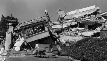
The first victims of the earthquake were people who ran out to the street and were struck by falling masonry, as the stone decorations on many of the buildings crashed to the ground. Many were killed instantly when buildings collapsed on them, but others were buried in the rubble. Most of the deaths were in the city centres.
https://my.christchurchcitylibraries.com/hawkes-bay-earthquake/
Primary Source, National Library of New Zealand, Reliable
We can see lots of rubble on the streets, telephone wires are damaged, heavy smoke potentially from fires
National Library of New Zealand
Primary Source, MTG Hawkes Bay is a museum and reliable
Buildings are nearly completely destroyed
MTG Hawke's Bay
Primary Source, Reliable, Auckland Library
Shot from up high, likely on a hill or mountain
Auckland Libraries
Reliable, Primary Source, Auckland Libraries
Other buildings are damaged, but will have to be destroyed because of unrepairable damage
Auckland Libraries
Auckland Libraries, Primary Source, Reliable
This applies for almost all of the black and white images of Napier, but I believe most of them are legit if not all
Auckland Libraries
Primary Source, Reliable, Archives New Zealand
Automobile's and roads were destroyed, damaging newly placed infrastructure
Archives New Zealand Te Rua Mahara o te Kāwanatanga
Primary Source, Reliable, Government Ministry
Manatū Taonga, the Ministry for Culture and Heritage
Reliable, MTG Hawke's Bay, Primary Source
MTG Hawke's Bay
Hastings Street after the 1931 Hawke's Bay earthquake
MTG Hawke's Bay
Communication Infastructure damaged (Wairoa Post Office)
Archives New Zealand Te Rua Mahara o te Kāwanatanga
Medical Insitutions damaged (Nurses Hostel, Napier)
Alexander Turnbull Library
Earthquake damage
MTG Hawke's Bay
Streets appear to be wet, potentialy from damaged drainage
Hastings Street Napier
Hawke's Bay Knowledge Bank
Unemployment and hunger would have set in quickly, with food reserves being destroyed or contaminated
Hawke's Bay Earthquake, 1931
Auckland Libraries
Corner of Russell and Heretaunga streets, Napier Earthquake, 1931
Auckland Libraries
Earthquake damaged house
MTG Hawke's Bay
Road damaged by the Hawke's Bay earthquake
Alexander Turnbull Library
Dramatic Scenes, complete devestation never really seen since in NZ's history
Napier Earthquake, 1931
Auckland Libraries
Healthcare and quality of living steeply went down as a result of the Earthquake
Napier Nurses' Home, 1931
Auckland Libraries
Napier earthquake rubble, 1931
Auckland Libraries
Hawke's Bay earthquake images
Manatū Taonga, the Ministry for Culture and Heritage
Building Remains
Hawke's Bay Knowledge Bank
1931 Hawke's Bay Earthquake - Town Hall, Napier
Archives New Zealand Te Rua Mahara o te Kāwanatanga
Port Ahuriri, Napier Earthquake, 1931
Auckland Libraries
Earthquake Damage, Ahuriri
MTG Hawke's Bay
Browning Street, Napier Earthquake, 1931
Auckland Libraries
Collapsed bridge, Napier Earthquake, 1931
Auckland Libraries
AMP Society Building, Napier Earthquake, 1931
Auckland Libraries
Napier Earthquake, 1931
Auckland Libraries
Napier Earthquake, 1931
Auckland Libraries
1931 Hawke's Bay Earthquake - Unidentified Damaged Street
Archives New Zealand Te Rua Mahara o te Kāwanatanga
Napier Nurses' Home, 1931
Auckland Libraries
Natural Damage
The local landscape changed dramatically, with the coastal areas around Napier being lifted by around two metres. The most noticeable land change was uplifting some 40 km2 of sea-bed to become dry land. This included Ahuriri Lagoon which was raised more than 2.7 metres and drained 2230 hectares of the lagoon. Today, this area is the location of Hawkes Bay Airport, housing and industrial developments and farmland.
https://en.wikipedia.org/wiki/1931_Hawke%27s_Bay_earthquake
Severe damage to the coast, potential rise/fall in area's?
Earthquake damage, Hawke's Bay coastline
MTG Hawke's Bay
Earthquake damage, Hawke's Bay coastline
MTG Hawke's Bay
Earthquake damage, Hawke's Bay coastal road
MTG Hawke's Bay
Costal Slips and Landslides would have likely been damaged
Slip, Hawke's Bay Coastline
MTG Hawke's Bay
Reconstruction
On 11 March 1931 the government-appointed magistrate J. S. Barton and engineer L. B. Campbell as commissioners for Napier. Together with local committees, they had the daunting task of organising reconstruction. This included restoring water supplies, replacing sewers, and repairing and inspecting houses before they could be reoccupied. Local survey plans and land titles had been destroyed, so all properties were resurveyed, and interim titles were issued.
Few insurance policies covered earthquakes, and many insurers refused to pay for fire damage that resulted from the quake. In 1931 Parliament passed the Hawke’s Bay Earthquake Act, which provided loans for local companies and individuals to rebuild their premises. Because of the economic depression, however, the funds granted were far from adequate, and repayment terms were harsh. Much of the money for recovery came from charity, which poured in during the weeks after the quake
OTAGO DAILY TIMES, ISSUE 21254, 7 FEBRUARY 1931, PAGE 12
Uploaded by DigitalNZ user Duncan Roper
Drainage Repairs
MTG Hawke's Bay
Wairoa River Bridge, Wairoa, Hawke's Bay, under repair after the 1931 Hawke's Bay earthquake
Alexander Turnbull Library
Anzac day in earthquake-stricken Hawke's Bay
Auckland Libraries
REBULLDING NAPIER (Evening Post, 16 July 1932)
National Library of New Zealand
NAPIER EARTHQUAKE (Evening Post, 20 May 1937)
National Library of New Zealand


