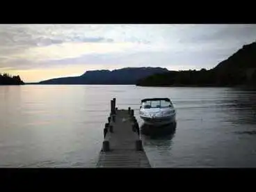
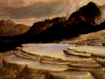
Eruption of Mt Tarawera on 10 June 1886
A DigitalNZ Story by Zokoroa
Before and after images of Mt Tarawera, the Pink and White Terraces, and villages
Mount Tarawera, Tarawera, Volcano, Eruption, Earthquake, Disasters, Pink and White Terraces, Pink Terrace, White Terrace, Te Wairoa, Buried Village, Guide Sophia
Mount Tarawera erupted In the early hours of the morning of 10 June 1886 following a series of 30 earthquakes in the Rotorua region. Molten rock, ash and smoke were thrust up from its three peaks to ten kilometres high. Eleven days prior to the eruption the spectre of a war canoe being paddled was seen by local Māori and tourists being escorted by Guide Sophia Hinerangi after the waters of Lake Tarawera rose suddenly and then subsided. The phantom waka was regarded by local tohunga Tūhoto Ariki as an omen of pending disaster.
The eruption caused a 17-km-long rift which split Mount Tarawera, starting from the Wahanga peak at the mountain's northern end and extending in a southwesterly direction through Lake Rotomahana, and became known as the Waimangu Volcanic Rift Valley. The silica hot springs at Lake Rotomahana, known as the Pink and White Terraces, were mostly destroyed with fragments found underwater. Several settlements were destroyed or buried in ashfall. Estimates of the number of people who lost their lives varied from approximately 120 to 153 people. One of the settlements, Te Wairoa, is now known as ‘The Buried Village’ and has become a tourist attraction. Many survivors of the Mt Tarawera eruption were offered land to resettle at Whakarewarewa and Ngapuna in Rotorua. Guide Sophia also moved to Whakarewarewa where she continued her guiding work with tourists.
The volcano Mt Tarawera & Lake Tarawera are located 24 kms southeast of Rotorua
Mt Tarawera has 3 peaks: Wahanga Dome (north), Ruawahia Dome (centre & highest at 1,111 metres) & Tarawera Dome (south)
University of Otago
On 31 May 1886, a ghostly war canoe was seen on Lake Tarawera after the water suddenly rose then fell
Alexander Turnbull Library
The waka & paddlers were seen from a boat with Māori & European visitors accompanied by Guide Sophia Hinerangi
Sophia (born c.1830-34 to Kōtiro Hinerangi of Ngāti Ruanui & Scotsman Alexander Grey/Gray) had been guiding for c.16 yrs
Auckland Libraries
Guide Sophia consulted tohunga Tūhoto Ariki who regarded the waka wairua (spirit canoe) as a bad omen
He prophesied Māori to be punished for exploiting Terraces with tourism & not paying due respect to ancestoral values
Europeana
On 10 June 1886, a series of 30 earthquakes occurred after midnight & Mt Tarawera's 3 domes erupted at 2.45am
The earthquakes were felt throughout Nth Island. The eruption lasted for 6 hours & sent molten rocks & ash 10 kms high.
Te Whare o Rehua Sarjeant Gallery
A 17-km-long rift had split Mount Tarawera from the Wahanga peak at northern end to Lake Rotomahana in south-west
Amount & height of volcanic material measured 5 (> 1 km3) on the Volcanic Explosivity Index (VEI) scale of 0-8 (highest)
Auckland Libraries
At Lake Rotomahana, the silica hot springs (Pink & White Terraces) were mostly destroyed with fragments found underwater
The Terraces were regarded as the "8th Wonder of the World" & tourists would bathe in the natural hot pools
Alexander Turnbull Library
Several settlements were destroyed or buried in ashfall, including Te Wairoa (nowadays 'The Buried Village' to tourists)
The settlements destroyed or buried included Te Tapahoro, Moura, Te Ariki, Totorariki, and Waingongongo
Alexander Turnbull Library
Locals formed search parties & estimates of the number who lost their lives varied from c.120 - 153
The Tarawera eruption was the largest & with the most loss of lives in NZ during the past 5 centuries
Hocken Collections - Uare Taoka o Hākena, University of Otago
The Government sent a group of surveyors to assess the area
The survey party's findings were recorded in "The eruption of Tarawera : a report to the Surveyor-General" (1886)
Auckland Libraries
Map of Tarawera eruption which covered land with millions of tonnes of ash & debris, transformed lakes & flattened bush
Ash was deposited as far east as East Cape and on ships at sea in the Bay of Plenty
Museum of New Zealand Te Papa Tongarewa
1. Images of the eruption on 10 June 1886
After midnight there was a series of 30 violent earthquakes which were felt throughout the North Island
Mount Tarawera in Eruption June 10 1886 as seen from Wairoa
Hocken Collections - Uare Taoka o Hākena, University of Otago
At 2.45am, Mt Tarawera's 3 domes - Wahanga, Ruawahia & Tarawera - erupted & fountains of lava began to flow
Eruption of Mount Tarawera
Auckland Libraries
A cloud of ash was thrust 10 kms skywards
Mount Tarawera in Eruption, June 10 1886. From near white Terrace
Hocken Collections - Uare Taoka o Hākena, University of Otago
Flickers of lightning were seen
Mount Tarawera in Eruption June 10 1886 as seen from Wairoa
Hocken Collections - Uare Taoka o Hākena, University of Otago
The ash filled the sky which became pitch black the following day from Rotoiti to Maketū
Photograph: Mount Tarawera in Eruption 10 June 1886 As Seen From Wairoa
Canterbury Museum
SurvIvor Ina Haszard's painting in 1935 which she painted from her memory & her sister Clara's description
Mt Tarawera in eruption
Museum of New Zealand Te Papa Tongarewa
The rising magma turned the groundwater & lake water into steam
Showing the eruption from the top of Mount Tarawera in 1886
Auckland Libraries
Mount Tarawera Eruption : Fubarole Peaks, Rotomahana
Museum of New Zealand Te Papa Tongarewa
Mount Tarawera Eruption : Untitled
Museum of New Zealand Te Papa Tongarewa
Mount Tarawera Eruption : Untitled
Museum of New Zealand Te Papa Tongarewa
[Mount Tarawera eruption]
Museum of New Zealand Te Papa Tongarewa
Craters on the south-west side of the mountain blasted open
Burton Bros: Interior of the crater of Mount Tarawera after the eruption
Alexander Turnbull Library
A crack 17 kms long formed which extended as far south as Waimangu & spewed steam, boiling mud & ash
Showing a rift in the top of Mount Tarawera
Auckland Libraries
The steam caused explosions that blasted out soil as huge piles of hot mud which destroyed vegetation
Showing a group of people crossing the mud near Te Ariki, Mount Tarawera (background) after the eruption in 1886
Auckland Libraries
Locals formed search parties:
Locals formed search parties to look for survivors
Some people were able to shelter in buildings & others had fled to Rotorua 16 kms away
Auckland War Memorial Museum Tāmaki Paenga Hira
Tohunga Tūhoto Ariki was dug from his whare 4 days later & taken to Rotorua Government Sanatorium where he later died
Archives New Zealand Te Rua Mahara o te Kāwanatanga
Survivors at Te Wairoa included 62 people who had sheltered with Guide Sophia in her whare
(The number who'd sheltered with her was estimated by Guide Sophia)
Alexander Turnbull Library
Schoolmaster's wife Amelia Haszard was dug out alive & two of her daughters had escaped earlier
However, Schoolmaster Charles Haszard, his son & 2 of his 4 daughters & a nephew died inside the schoolhouse
Auckland Libraries
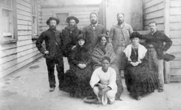
Group photo of some of the survivors at Te Wairoa which included Guide Sophia
Hocken Collections - Uare Taoka o Hākena, University of Otago
Estimates of the number of people who lost their lives varied from approx. 120 to 153 people
Alexander Turnbull Library
Map gives an estimate of the number of deaths at different localities
Manatū Taonga, the Ministry for Culture and Heritage
Government sent surveyors to assess the damage:
The Government appointed a survey party led by Stephenson Percy Smith (Assistant Surveyor-General)
Alexander Turnbull Library
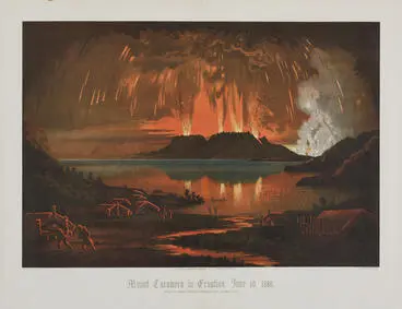
The survey party's findings were recorded in "The eruption of Tarawera : a report to the Surveyor-General" (1886)
British Library digitised image from page 74 of "The Eruption of Tarawera: a report to the Surveyor General [With illustrations.]"
The British Library
The 84 paged report also included 47 leaves of plates
British Library digitised image from page 168 of "The Eruption of Tarawera: a report to the Surveyor General [With illustrations.]"
The British Library
A summarised account of the operations of the rescue & survey teams compiled by the Otago Witness (02 July 1886)
National Library of New Zealand
Settlements at Te Wairoa, Te Ariki, Te Tapahoro, Moura, Totorariki, & Waingongongo were destroyed
Many survivors of the eruption were offered land to resettle at Whakarewarewa & Ngapuna in Rotorua
Auckland Libraries
>>>>>>>>>>>>>>>>>>>>>>>>>>
2. IMAGES Before & After the eruption
2.1 Mt. Tarawera
Before THE ERUPTION:
Mt. Tarawera
Mt. Tarawera began forming c.23,500 years ago within the Ōkataina Volcanic Centre which lies within Taupō Volcanic Zone
Alexander Turnbull Library
Mt Tarawera was built up over a series of volcanic eruptions around 1314 AD
Kinder, John, 1819-1890 :Tarawera Mountain. From above Te Ariki - On road to Rotomahana. J Kinder D. D. del. 1864. J. McKean [del]
Alexander Turnbull Library
Te Arawa people had settled in the area and buried their dead on the slopes of Mt Tarawera
Tarawera
Auckland Libraries
AFTERWARDS:
Mt. Tarawera
Museum of New Zealand Te Papa Tongarewa
Mount Tarawera after the eruption
Auckland Libraries
Mount Tarawera Eruption : Tarawera shortly after Eruption
Museum of New Zealand Te Papa Tongarewa
Top of Mount Tarawera - SW end
Museum of New Zealand Te Papa Tongarewa
The rift in the top of Mt Tarawera
Museum of New Zealand Te Papa Tongarewa
Crater of Mount Tarawera after the eruption of 1886 - Photograph taken by George Dobson Valentine
Alexander Turnbull Library
New crater lake at Mount Tarawera after the 1886 eruption - Photograph taken by Charles S Spencer
Alexander Turnbull Library
Showing Mount Tarawera after the eruption in 1886
Auckland Libraries
2.2 Rotomahana & the Pink & White Terraces
BEFORE THE ERUPTION:
The Pink and White Terraces were considered as the "8th Wonder of the World". One of the first Europeans to visit Lake Rotomahana was Ernst Dieffenbach in June 1841 when on a survey for the New Zealand Company. The description of his visit to the Lake and the Terraces in his book “Travels in New Zealand” created international interest in the Pink and White Terraces.
Mt. Rotomahana & the Pink & White Terraces (considered as the "8th Wonder of the World")
Ernst Dieffenbach's visit during June 1841 described in his book "Travels in New Zealand" created international interest
Alexander Turnbull Library
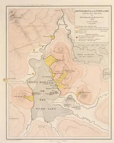
A map (1859) of Lake Rotomahana & the Terraces which were 1.5 kms apart on the Lake's western & northeastern shores
Rotomahana or the Warm Lake and the hot springs By Dr Ferdinand von Hochstetter
Auckland Libraries
Tourists included Sir George Grey in 1849, Alfred Duke of Edinburgh in 1869, & novelist Anthony Trollope in 1874
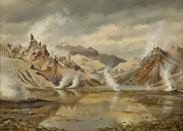
Pink and White Terraces, Lake Rotomahana and Mount Tarawera
Hocken Collections - Uare Taoka o Hākena, University of Otago
Painting by J.C. (John Barr Clark) Hoyte who was born in England & lived in NZ from 1860-1879
The Pink and White Terraces
Te Whare o Rehua Sarjeant Gallery
The Pink Terrace
Known as Te Ōtūkapuarangi (“The fountain of the clouded sky”) to the Tūhourangi people
Auckland Libraries
Tiers of silica basins went from marble white at base, to ice pink, to roseate, to primrose at top. (Artist unknown)
Pink terraces
Museum of New Zealand Te Papa Tongarewa
Cup-shaped pools fringed with stalactites & filled with blue (cerulean & cobalt tints) water (Photo: Charles Spencer)
Pink Terrace
Museum of New Zealand Te Papa Tongarewa
The Terrace descended 26 metres & was wider at top (c.73m) than at the bottom (c.23m). (Photo: Charles Spencer)
Pink Terrace
Museum of New Zealand Te Papa Tongarewa
The Terrace covered 2 hectares. (Photographer: Alfred Burton)
Pink Terrace
Museum of New Zealand Te Papa Tongarewa
The Pink Terraces, Rotomahana
Alexander Turnbull Library
The heated water attracted bathers
Bathing at the Pink Terraces
Manatū Taonga, the Ministry for Culture and Heritage
The White Terrace
Known as Te Tarata ("The tattooed rock”) looked like a foaming cascade of water turned to stone (Painter: J.C. Hoyte)
Alexander Turnbull Library
Descended 30 metres from geyser-fed spring & was 244 metres long & covered 2.8 hectares. (Painter: Charles Blomfield)
White Terraces
Museum of New Zealand Te Papa Tongarewa
At the top was a 2 metre thick rim enclosed pool of boiling water. (Photographer: Alfred Burton)
White Terrace - from the top
Museum of New Zealand Te Papa Tongarewa
The overflow from the pool at the top cascaded down, creating baths of water with decreasing warmth in temperature
White Cup basins overflowing [White Terraces, Tarawera]
Museum of New Zealand Te Papa Tongarewa
As the water cooled, deposits of silica built up on the scalloped walls, forming intricate patterns
Hot Water Cups, White Terrace
Museum of New Zealand Te Papa Tongarewa
The Giant Buttress was a feature of the White Terrace. (Photographer unknown)
Giant Buttress, White Terrace, Lake Rotomahana, Rotorua
Alexander Turnbull Library
Photographer: Hemas & Hanna (Auckland Firm): Charles Hemus & John Robert Hanna
White Terraces at Rotomahana
Alexander Turnbull Library
White Terrace Cups overflowing, Lake Rotomahana, 1886
Auckland Libraries
Māori boy sitting on the edge of one of the hot water basins. (Photographer: Alfred Burton)
The Hot Water Basins, White Terraces
Hocken Collections - Uare Taoka o Hākena, University of Otago
Guide Sophia would take tourists on sight-seeing boat rides across Lake Rotomahana to the Terraces
Sophia Hinerangi on the Terraces at Rotomahana - Photograph taken by George Dobson Valentine
Alexander Turnbull Library
Backhouse, John Philemon, 1845-1908 :White Terrace. [188-?].
Alexander Turnbull Library
Hot Bath, White Terrace. From the album: Frances Fenwick's Album of New Zealand views
Museum of New Zealand Te Papa Tongarewa
Spencer, Charles S 1854-1933: Group of tourists on the White Terraces at Rotomahana
Alexander Turnbull Library
Afterwards:
First Party at Rotomahana after Erutption. No.358 C.Spencer Photo
Auckland Libraries
Charles Blomfield had been holidaying with his daughter Mary at Lake Rotomahana & produced several oil paintings
Rotomahana after the eruption
Auckland Art Gallery Toi o Tāmaki
Showing Rotomahana ten days after the eruption of Mount Tarawera in 1886
Auckland Libraries
Mount Tarawera eruption: Rotomahana immediately after eruption
Museum of New Zealand Te Papa Tongarewa
A 17-km rent from Mt Tarawera to Lake Rotomahana formed the Waimangu Volcanic Rift Valley
The rent in Rotomahana from the Black Crater - Photograph taken by George Dobson Valentine
Alexander Turnbull Library
A series of craters were formed in the Rift Valley with the 50m Southern Crater nearest Rotomahana
Valentine, George Dobson, 1852-1890 :South crater, the termination of Rotomahana rent
Alexander Turnbull Library
Southern Crater's floor was filled by 2 metre deep Emerald Pool with cold water mainly from rainfall
Waimangu Thermal Valley.
Archives New Zealand Te Rua Mahara o te Kāwanatanga
The Echo Crater in the Waimangu Volcanic Rift Valley became the hot spring, Frying Pan Lake (Waimangu Cauldron)
Showing Fryingpan Flat and Waimangu basin on Mount Tarawera...
Auckland Libraries
Waimangu Geyser (means “black water” after its black appearance from rocks, mud & ash) formed & was active from 1900-04
Waimangu Geyser. New Zealand
MOTAT
Showing boling mud after the eruption of Mount Tarawera in 1886
Auckland Libraries
The Pink & White Terraces had disappeared
Research from 2011-2014 by GNS, Woods Hole Oceanographic Inst. (US), & Univ of Waikato found no trace on land
NZ On Screen
Lake Rotomahana had expanded in size as it filled part of the newly formed Waimangu Volcanic Rift Valley
The Lake filled the new valley to four times its original length & its water level was 30 metres higher than before
Auckland Libraries
2.3 Settlements
The area around Mount Tarawera was home to Tūhourangi and Ngāti Rangitihi iwi who form part of the Te Arawa confederation of tribes. During the mid-1840s, a missionary post was established at Lake Tarawera by the Anglican Reverend Seymour Mills Spencer. and explorers and traders began to arrive. The Pink And White Terraces became a popular destination for tourists who would stay at Te Wairoa at Joseph McRae's Rotomahana Hotel and Charles Humphrey's Terrace Temperance Hotel. They'd take sight-seeing boat rides across Lake Rotomahana to the Terraces with locals, including Guide Sophia. See an account by Vaughan Yarwood (2003). "The night Tarawera awoke". New Zealand Geographic (65).
Settlements at Te Wairoa, Te Ariki, Te Tapahoro, Moura, Totorariki, & Waingongongo had been destroyed
National Library of New Zealand
a. Te Wairoa
BEFORE THE ERUPTION:
Te Wairoa settlement
Māori & European settlement founded c. 1850 by Rev. Seymour Mills Spencer about 6kms from the Terraces
Auckland Libraries
Hinemihi Meeting House ("The house with the golden eyes”: gold sovereigns used instead of paua shells in carvings' eyes)
Māori House, Wairoa
Hocken Collections - Uare Taoka o Hākena, University of Otago
Mission Station Chapel
Chapel at Te Wairoa Mission Station before Tarawera eruption, 1860-86
Auckland Libraries
Maling, Christopher 1843-1917 :Zion chapel, Tarawera, New Zealand. Nth Island. 1857?
Alexander Turnbull Library
Tourists would stay at Te Wairoa to visit the Pink & White Terraces & Guide Sophia Hinerangi would take groups on tour
Harvey, Robert, 1848-ca 1920: Sophie (Tai Awhio). New Zealand. Maoria guide. [1880s]
Alexander Turnbull Library
Guide Sophia Hinerangi cooking at Te Tekapo Flat, Rotomahana, Rotorua district
Alexander Turnbull Library
Accommodation for tourists was at Joseph McRae's Rotomahana Hotel & Charles Humphrey's Terrace Temperance Hotel
McRae's Hotel with the proprietor, Mr McRae, standing talking to a Maori chief
Hocken Collections - Uare Taoka o Hākena, University of Otago
Te Wairoa schoolhouse with Schoolmaster Charles Haszard
Te Wairoa schoolhouse, Lake Tarawera, 1884
Auckland Libraries
The Haszard family home where Charles & Amelia & their son (Charles) & 4 daughters (Clara, Ina, Edna & Mona) lived
The Haszard family and home at Wairoa before the eruption
Alexander Turnbull Library
Afterwards:
Te Wairoa settlement
Alexander Turnbull Library
WAIROA A SCENE OF DESOLATION. (Taranaki Herald, 12 June 1886)
National Library of New Zealand
Subsidence on the road to Te Wairoa, 1886
Auckland Libraries
Ruins of mission chapel at Te Wairoa...1886
Auckland Libraries
Mission Church, Wairoa after the eruption
Museum of New Zealand Te Papa Tongarewa
Old Mill, Wairoa, After Eruption June 10 1886
Hocken Collections - Uare Taoka o Hākena, University of Otago
A number of people took refuge in the Hinemihi Meeting House which did not collapse
Hinemihi meeting house at Te Wairoa, after the Mt Tarawera eruption - Photograph taken by Edmund Wheeler and Son
Alexander Turnbull Library
Te Wairoa, McRaes Hotel, Sophias whare and Terrace hotel
Rotorua Museum of Art & History Te Whare Taonga o Te Arawa
At McRae's Rotomahana Hotel, people had to leave one room when the roof collapsed & then leave the hotel
McRae's Hotel at Te Wairoa after the eruption, 1886
Auckland Libraries
One hotel guest died when the veranda collapsed, but the others made it to safety & took refuge In Guide Sophia's whare
Back of McRae's Hotel, Wairoa
Hocken Collections - Uare Taoka o Hākena, University of Otago
Guide Sophia estimated about 62 people sheltered with her in her whare with reinforced timber walls & high-pitched roof
Sophia's Whare
Auckland Libraries
The Terrace Temperance Hotel (also known as Humphreys’ Boarding House) was damaged
Humphrey's Boarding House After Eruption June 10 1886
Hocken Collections - Uare Taoka o Hākena, University of Otago
Another view of the Terrace Temperance Hotel which had caved in but Hotelkeeper Charles Humphreys & his wife survived
Ruins of Terrace hotel, Te Wairoa
Rotorua Museum of Art & History Te Whare Taonga o Te Arawa
The house of Captain Herbert Way, who'd served in Waikato Militia as Ensign & later Captain during NZ Wars, was ruined
Showing the ruins of Captains Ways house at Te Wairoa after the eruption of Mount Tarawera in 1886
Auckland Libraries
Schoolmaster Charles Haszard's daughters Clara (aged 22) & Ina (16) escaped when schoolhouse roof began to collapse
Mr Hazard's House, Wairoa, after eruption June 10 1886
Museum of New Zealand Te Papa Tongarewa
Two surveyors staying with the Haszards rushed outside when the roof began to collapse & sheltered in the fowl house
H. Lundis (left) and John Cunningham Blythe standing outside fowl house where they had taken shelter from the eruption of Mount Tarawera
Alexander Turnbull Library
Haszard's wife Amelia, whose 43rd birthday was earlier that evening, was pinned under a beam & rescued the next day
Martin, Josiah, 1843-1916 :Photograph of Amelia Haszard
Alexander Turnbull Library
THE ESCAPE OF MRS HASZARD. (Nelson Evening Mail, 11 June 1886)
National Library of New Zealand
Charles Haszard had observed the eruption from his verandah & died a few hours later when his house collapsed
Martin, Josiah, 1843-1916 :Photograph of Charles Albert Haszard
Alexander Turnbull Library
Haszard's son Charles (aged 10), daughters Edna (6) & Mona (4) & nephew Charles died under collapsed roof & volcanic mud
Ruins of Charles Haszard's Te Wairoa school house after the Tarawera eruption
Alexander Turnbull Library
Group photo of some of the survivors included Guide Sophia & Hotelkeepers Joseph McRae & Mr & Mrs Humphreys
Survivors, Tarawera Eruption
MTG Hawke's Bay
After the eruption, Guide Sophia moved to Wharewarewa where she continued her guiding work until her death on 4 Dec 1911
Sophia, The Guide, Whakarewarewa. (Protected 15.3.98.) Beattie and Sanderson. Auckland.
Auckland Libraries
Guide Sophia's account of the eruption was told to E. I. Massey who published "The Tarawera eruption, 1886" in 1903
The Tarawera eruption, 1886 / by E.I. Massy.
National Library of New Zealand
B. Te Ariki
Before the eruption:
Te Ariki Pa
Alexander Turnbull Library
Group outside Tamahana's kainga, Te Ariki
Alexander Turnbull Library
Young Maori girl at Te Ariki Pa
Alexander Turnbull Library
AFTERWARDS:
Water course worn in mud near Te Ariki, after eruption June 10 1886
Museum of New Zealand Te Papa Tongarewa
Mounts Tarawera and Ruawahia from Te Ariki
Alexander Turnbull Library
'Our Camp', near Te Ariki, after eruption June 10 '86
Museum of New Zealand Te Papa Tongarewa
C. Moura Settlement
Afterwards:
Moura settlement
Museum of New Zealand Te Papa Tongarewa
Site of Moura settlement, Lake Tarawera, after eruption June 10 1886
Museum of New Zealand Te Papa Tongarewa
D. Lake Tikitapu (Blue Lake)
Before:
Lake Tikitapu, Wairoa
Museum of New Zealand Te Papa Tongarewa
Tikitapu Bush
Hocken Collections - Uare Taoka o Hākena, University of Otago
Tikitapu Bush
Museum of New Zealand Te Papa Tongarewa
AFTERWARDS:
Photograph: Tikitapu Lake after Eruption, 10 June 1886
Canterbury Museum
Tikitapu Bush after Eruption June 10 1886
Hocken Collections - Uare Taoka o Hākena, University of Otago
Fissure in Road near Tikitapu Bush after Eruption June 10 1886
Hocken Collections - Uare Taoka o Hākena, University of Otago
3. Further afield beyond Tarawera district
Earthquakes felt in Rotorua, Tauranga, Taupo, Napier, Wanganui & New Plymouth
National Library of New Zealand
Tauranga
The earthquakes were felt at Tauranga & ash covered the buildings
National Library of New Zealand
Auckland
In Auckland, the sound of the eruption was thought to be distress signals of war vessel going ashore at the Manukau bar
National Library of New Zealand
Blenheim
The earthquakes were felt as far south as Blenheim
National Library of New Zealand
Ash from the eruption covered much of the Bay of Plenty as shown in this map compiled by Prof A. P. W. Thomas in 1886
A layer of 2.5 cms ash fell over Te Puke township & surrounding farmland; & about 7.5cms over Whakatāne
Manatū Taonga, the Ministry for Culture and Heritage
4. Nowadays
Lake Tarawera
Auckland Libraries
Lake Rotomahana had engulfed Lake Rotomakariri & expanded to 20 times it's original size & additional 40 metres in depth
Lake Rotomahana
Auckland Libraries
Terrain map of the Waikaremoana and Whirinaki area which includes the Lake and surrounding forests (2003)
Waikaremoana & Whirinaki recreation areas
Tauranga City Libraries
Inferno Crater Lake at Waimangu with an underwater geyser rises & falls up to 9 metres approximately every 38 days
Inferno Crater, Waimangu
Alexander Turnbull Library
Te Wairoa "The Buried Village" which has become a tourist attraction
Te Wairoa Buried Village, 1966
Auckland Libraries
Te Wairoa Buried Village tea rooms, 1966
Auckland Libraries
RNZ (12 Jan 2023): Museum stop: Buried Village and Museum of Te Wairoa (9:37 min)
Museum stop: Buried Village and Museum of Te Wairoa
Radio New Zealand
5. FIND OUT MORE:
Auckland Museum, 'The eruption of Mt Tarawera', URL: https://www.aucklandmuseum.com/discover/collections/topics/the-eruption-of-mt-tarawera
Curnow, Jenifer. 'Hinerangi, Sophia', Dictionary of New Zealand Biography, first published in 1993, updated July, 2015. Te Ara - the Encyclopedia of New Zealand, https://teara.govt.nz/en/biographies/2h37/hinerangi-sophia
McSaveney, Eileen; Stewart, Carol & Leonard, Graham: 'Historic volcanic activity - Tarawera', Te Ara - the Encyclopedia of New Zealand, http://www.TeAra.govt.nz/en/historic-volcanic-activity/page-2
Remuera Heritage: 'Purewa – Amelia and Charles Haszard', URL: https://remueraheritage.org.nz/story/purewa-amelia-and-charles-haszard/
Rotorua Museum: 'Mount Tarawera', URL: https://www.rotoruamuseum.co.nz/discover/tarawera-te-maunga-tapu/
Thomas, A. P. W. (1888), 'Report on the eruption of Tarawera and Rotomahana', N.Z. (Wellington, Govt. Printer). In "The Pamphlet Collection of Sir Robert Stout: Vol 68". URL: https://nzetc.victoria.ac.nz/tm/scholarly/tei-Stout68-t21-front-d3.html
Wikipedia: '1886 eruption of Mount Tarawera', URL: https://en.wikipedia.org/wiki/1886_eruption_of_Mount_Tarawera
Wikipedia: 'Pink and White Terraces', URL: https://en.wikipedia.org/wiki/Pink_and_White_Terraces
Yarwood, Vaughan (2003). 'The night Tarawera awoke'. New Zealand Geographic (65).
A list of additional print & digital publications can be searched on the National Library of New Zealand's catalogue: https://natlib.govt.nz/
Books/Reports/Catalogues also include:
Report on the Tarawera Volcanic District by Prof F.W. Hutton (1887)
Published in "The Pamphlet Collection of Sir Robert Stout": Vol 67 ( (Govt Printer, 1887)
Victoria University of Wellington
Videos:
Manatū Taonga (2011): Roadside Stories: The eruption of Mt Tarawera
Youtube video: 4:47min)
Manatū Taonga, the Ministry for Culture and Heritage
NZOnScreen (2011): Tarawera
The documentary features an animated re-creation of the eruption, archival images, & interviews with descendants
NZ On Screen
Museum of NZ Te Papa Tongarewa (2019): He Paki Taonga i a Māui: Te Paea me te Waka Wairua | Te Paea and the Ghost Waka
Youtube video (7.44 min)
Museum of New Zealand Te Papa Tongarewa
Audio interviews:
RNZ (2011): Commemoration ceremonies include GNS exploration of Lake Rotomahana which located the Terraces (11:40 min)
Radio New Zealand
RNZ (2014): Interviews with Willy Bennett & Roger Delamere Dansey who recall the night of 10 June 1886
Radio New Zealand
RNZ (2016): Sound Archives: The Mt Tarawera eruption (10:03 min)
Eyewitness accounts of the Tarawera eruption
Radio New Zealand




![British Library digitised image from page 74 of "The Eruption of Tarawera: a report to the Surveyor General [With illustrations.]" Image: British Library digitised image from page 74 of "The Eruption of Tarawera: a report to the Surveyor General [With illustrations.]"](https://thumbnailer.digitalnz.org/?resize=770x&src=https%3A%2F%2Flive.staticflickr.com%2F2878%2F11183799976_40d64238cd_z.jpg&resize=368%253E)
![British Library digitised image from page 168 of "The Eruption of Tarawera: a report to the Surveyor General [With illustrations.]" Image: British Library digitised image from page 168 of "The Eruption of Tarawera: a report to the Surveyor General [With illustrations.]"](https://thumbnailer.digitalnz.org/?resize=770x&src=https%3A%2F%2Flive.staticflickr.com%2F5525%2F11185471214_d9c53c603b_z.jpg&resize=368%253E)


