A history of Garden Place, Hamilton
A DigitalNZ Story by Zokoroa
A pictorial history of the transformation of the inner city of Hamilton to create Garden Place by excavating a large hill. Over the years the layout design of Garden Place has changed, as have the types of businesses on its perimeter.
Hamilton, Kirikiriroa, Hamilton Hill, Garden Place, Garden Place Hill, Parking, Garden, Place, Hill, History, Ngati Wairere, Waikato War
BEFORE & AFTER: HAMILTON HILL TRANSFORMED TO GARDEN PLACE
When you look at the Garden Place square in the centre of Hamilton, try to imagine a ten metre high hill stretching from Victoria Street back towards the upper slope along Anglesea Street where Wintec stands. Garden Place was originally part of a ridge called Te Kōpū Mānia o Kirikiriroa by hapū Ngāti Wairere. After the arrival of the 4th Militia and settlers during the 1860s, Kirikiriroa was named Hamilton. The ridge became known as Hamilton Hill that divided the town centre into north and south sides.
In the late 1930s, Hamilton Hill was levelled and the land at Garden Place by Victoria Street was initially used as a carpark and then as military site during World War II. Post-WWII, Garden Place resumed being a carpark until the late 1960s when it evolved into becoming a public square with gardens, lawn, paved walking areas and fountains.
The history of the hill in pre-European times as a garden for the Ngāti Wairere, the arrival of colonial settlers and missionaries, occupancy by the 4th Militia followed by the Armed Constabulary, the removal of the hill and the development of Garden Place over the decades is retold in photographs.

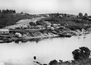
Garden Place was a hill that was part of a 10 metre high 'Hamilton Hill' that stretched from Victoria St to Anglesea St
Image: Garden Place fronting onto Victoria St with side road to housing on the Hill, 1930s
Hamilton City Libraries
Hamilton HIll was originally named 'Te Kōpū Mānia o Kirikiriroa' by Ngāti Wairere (see ridge at top rear of Ferrybank)
During 1860s, 4th Militia & settlers arrived at Ferrybank at bottom of Victoria St & Kirikiriroa was renamed Hamilton
Hamilton City Libraries

Gardens were developed along Garden Place Hill's frontage on Victoria Street by the Hamilton Beautifying Society in 1914
Hamilton City Libraries

As Hamilton Hill divided town's commercial centre into north & south sides, Anglesea St was cut into the Hill in 1939
Rather than build a tunnel, the cutting was made in the Hill where Wintec now stands to create Anglesea St
Hamilton City Libraries
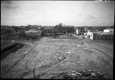
The Hill between Anglesea & Victoria Sts was then levelled to create Garden Place square & nearby shops & streets
(View from the remaining Hamilton Hill above Angelsea St through to Victoria St)
Hamilton City Libraries
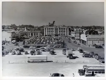
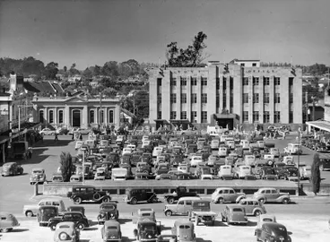
Carparks were created at the front half of Garden Place near Victoria St in 1940
Council subdivided & sold land on perimeter for development of businesses & built men's underground toilet by carpark
Waikato Museum Te Whare Taonga o Waikato
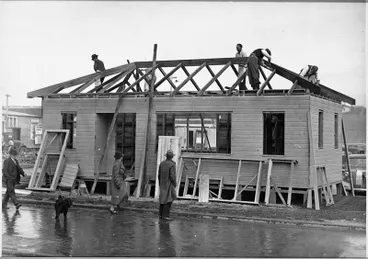
Air-raid trenches were dug in Garden Place in 1941 & Patriotic Hut for social activities & dormitory opened in Oct 1942
The trenches were built as a precaution for citizens in case the Japanese carried out air-raids
Hamilton City Libraries

Post-WW2, Garden Place resumed being a carpark; & Patriotic Hut became a Memorial Club in 1945 & was removed in 1949
A sundial was positioned at the front of Garden Place's carpark to coincide with Queen Elizabeth's tour in Dec 1953
Hamilton City Libraries

Over the decades, Garden Place has evolved from being a carpark to becoming a square with gardens, lawns & fountains
A pool with fountains installed (1968-70); pool replaced with paving (2000s) & 'pop up' fountain jets installed (2010s)
Hamilton City Libraries
1. Pre-European Hamilton Hill: Te Kōpū Mānia o Kirikiriroa
Garden Place was originally part of a ridge or promontory called Te Kōpū Mānia o Kirikiriroa (The Smooth Belly of the Long Pebbly Shore). It was named by the hapū Ngāti Wairere of the Waikato-Tainui iwi, who lived at the fortified Kirikiriroa Pā sited on the banks of the Waikato River between what is now London and Bryce Streets. Kirikiriroa means ‘long strip of cultivated land’. The ridge extended from what is now Ruakiwi Road down Hill Street, Tristram Street, through to Garden Place and onwards to Victoria Street. See: Wintec: A history of the land on which our city campus sits (pdf)
Garden Place was originally part of a ridge called Te Kōpū Mānia o Kirikiriroa by hapū Ngāti Wairere
Iwi o te Wiki - Ngāti Wairere.
National Library of New Zealand
Ngāti Wairere lived at Kirikiriroa Pā sited by the Waikato River between what is now London & Bryce Streets
Descendant of Kirikiriroa Pā occupant says Hamilton should have dual name
Radio New Zealand
Trip to Kirikiriroa Pā in 1842 recalled 24 years later
EARLY RECOLLECTIONS OF NEW ZEALAND. A TRIP TO THE WAIKATO TWENTY-FOUR YEARS AGO. (Daily Southern Cross, 17 December 1866)
National Library of New Zealand
The Hill was covered with rangiora and other native trees and ferns, and stands of kahikatea and tawa trees. Areas were burnt away to enable the planting of kūmara, rauruhe (fern root), other vegetables, and fruit trees on the northern slopes, and the cultivation of taro on the lower swampy area. There were also several puna (water springs) along the lower slopes. The berries provided food for native birds such as the kūkū (native pigeon) and the kōmako (bellbird), which were hunted and trapped.


There were stands of kahikatea & tawa, & fruit trees planted. Berries attracted native birds which were trapped & eaten.
Kahikatea
iNaturalist NZ — Mātaki Taiao

Kūmara, rauruhe (fern root), taro, & other vegetables, were planted & kept in storehouses (pataka) & pits
Kūmara
Manatū Taonga, the Ministry for Culture and Heritage
At the peak of the ridge there was a tūāhu (ceremonial altar), Te Ahurewa, where offerings were made to deities to bless the planting of crops and ensure a bountiful harvest. The hill was also used as an observatory for the transit of stars, including the rising of the constellation known as Matariki, to mark the timing for different phases of planting and harvesting.

At the peak a tūāhu (ceremonial altar), Te Ahurewa, used for offerings & observe transit of stars, including Matariki
Matariki
National Library of New Zealand
2. Arrival of Europeans & missionaries
From the 1830s, Europeans began arriving into the Waikato area and traded with local iwi. As well as introducing new tools and crops, they showed different ways of planting and harvesting. The first European met by Ngāti Wairere was Kore Hako who was captured at Aotea Harbour, Kawhia by a fishing party of Ngāti Koura from Te Rapa Pā which is located near the present-day Waikato Hospital. He later lived with Ngāti Wairere at Kirikiriroa Pa and introduced peach trees that grew around what is now Victoria Street.
During the 1840s, Christian missionaries began arriving and many Ngāti Wairere people converted to Christianity. The first "church" in the Hamilton City area, named Tohikitierangi, was a thatched, raupō building constructed at Kirikiriroa Pā for visiting Anglican missionaries who were based in the Waikato. On 16 January 1849, Reverend Benjamin Yates Ashwell and Reverend Robert Maunsell baptised 40 at Kirikiriroa Pā.
See: Hamilton City Council (2003): “Nga Tapuwae O Hotumauea” Maori landmarks on riverside reserves: Management Plan" (pdf)
Europeans began arriving in 1830s & missionaries in 1840s, & traded with Ngāti Wairere, many of whom became Christians
RECOLLECTIONS OF A WAIKATO MISSIONARY. NO.6, 1842. (Daily Southern Cross, 23 May 1867)
National Library of New Zealand

First 'church' constructed at Kirikiriroa Pā for visiting missionaries including Benjamin Ashwell who lived at Kaitohehe
Taylor, Richard, 1805-1873 :Mr Ashwell's house at Kaitotehe on the Waikato. May 31, 1847.
Alexander Turnbull Library
Kirikiriroa became part of Auckland Province, 1853
Following the Treaty of Waitangi in 1840, New Zealand became a British colony, initially as part of New South Wales. Later in May 1841, New Zealand was designated a Crown Colony, separate from New South Wales. In 1846, the British Parliament passed the New Zealand Constitution Act which allowed for the establishment of provinces. Governor Grey proclaimed on 10 March 1848 that New Zealand would comprise two provinces and each province would have an appointed Lieutenant-Governor: New Ulster (the North Island, north of the Patea River mouth with Auckland as the capital) and New Munster (the North Island south of the Patea River Mouth, the South Island and Stewart Island with Wellington as the capital).
The New Zealand Constitution Act 1852 was passed on 30 June 1852 and came into force on 17 January 1853. The Act created a General Assembly – an appointed Legislative Council and a House of Representatives - and divided New Zealand into six provinces with elected superintendents and provincial councils. Kirikiriroa was part of the Auckland Province.

Under NZ Constitution Act 1852, NZ was divided into six initial provinces & Kirikiriroa was part of Auckland Province
New Zealand Constitution Act 1852
Archives New Zealand Te Rua Mahara o te Kāwanatanga
3. Waikato War: Abandonment of Kirikiriroa & arrival of militia settlers
Ngāti Wairere abandoned Kirikiriroa Pā in 1864
During the New Zealand Wars, the campaign against Kīngitanga (Māori King Movement) in the Waikato began in July 1863. The British troops and colonial forces arrived at Rangiriri on 20 November 1863. They were supported during the ensuring battle by field artillery and cannon fire from their river gunboats Pioneer and Avon. Afterwards, Chief Te Pirihi Tomonui of Ngati Parekirangi hapū of Ngāti Wairere who'd supported the Kingitanga at Rangiriri Pā, sent word to Kirikiriroa Pā that the British troops were coming up river on a gunboat. On receiving the news, Ngāti Wairere abandoned Kirikiriroa Pā in 1864. Some travelled southwards into the King Country, whilst others travelled over the Waikato River to reoccupy other traditional Ngāti Wairere Pā at Hukanui, now known as Gordonton. [See Stuff.co.nz (10 Dec 2013): Elton Smallman, "Go back to your marae, that's what it's for]
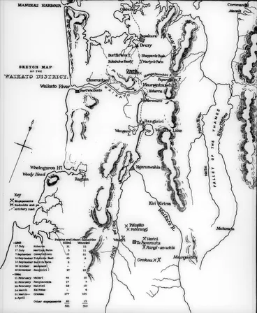
During Waikato War, on 20-21 Nov 1863, militia fought at Rangiriri with artillery & cannons from gunboats Pioneer & Avon
Map - engagements - Waikato campaigns
Hamilton City Libraries

Afterwards, Chief Te Pirihi Tomonui sent word to Kirikiriroa Pā that British troops were travelling up river by gunboat
Gunboat on the Waikato River
Manatū Taonga, the Ministry for Culture and Heritage

On hearing British troops were travelling up Waikato River, Ngāti Wairere abandoned Kirirkiriroa Pā in 1864
Naval Camp, Maungatawhiri Creek, 1864
Auckland Libraries
Kirikiriroa chosen as a militia post & soldiers & their families arrived Aug 1864
Ngāti Wairere's land at Kirikiriroa was confiscated by the Crown under the New Zealand Settlement Act 1863. Kirikiroa was chosen as one of the defensive militia posts to be established throughout the Waikato Region.
Volunteers were recruited from militia at Sydney and Melbourne by Lieutenant William Steele to form the 4th Waikato Regiment commanded by Lieutenant Colonel William Moule. The New Zealand Gazette Notice (5 August 1863) set out the critieria for recruitment and the terms under which grants of land would be made.
On 24 August 1864, an advance party of 118 soldiers from the 4th Battalion of the 4th Waikato Regiment arrived on the gunboat PS Rangiriri. Under the command of Captain William Steele, they occupied the abandoned Kirikiriroa Pā. They were followed by the rest of the Fourth Waikato Regiment who arrived with their families. The number of settlers totalled 1465 of which 432 were men, 282 were women and 751 were children.

Ngāti Wairere's land at Kirikiriroa was confiscated by the Crown under the New Zealand Settlements Act 1863
The New Zealand Settlements Act of 1863
Manatū Taonga, the Ministry for Culture and Heritage
Volunteer militia were recruited from Sydney & Melbourne under the conditions listed in NZ Gazette Notice (5 Aug 1863)
NEW ZEALAND (Wellington Independent, 15 August 1863)
National Library of New Zealand
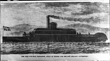
On 24 Aug 1864, 118 men of 4th Waikato Militia arrived with Capt William Steele on PS Rangiriri to set up a militia post
P S Rangiriri
Hamilton City Libraries
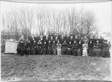
The rest of 4th Militia & families followed, bringing total number of settlers to 1465. (Group photo of reunion in 1890)
Veterans of the 4th Waikato Militia
Hamilton City Libraries
Work commenced by the Militia on building two redoubts located on elevated sites on opposite sides of the Waikato River near present-day Victoria Bridge. The intent was to secure the Waikato River and prevent any 'hostile' movements by Kingitanga. The Hamilton West Redoubt was built where the St Peter's Cathedral and adjacent areas by Grantham Street and Victoria Street are now located. On the eastern side, the redoubt, which was known as Moule's Redoubt, was built on the former site of the Tararahi Pā (also (also known as Tetarahi). The Pā had been occupied by Ngāti Parekirangi, a hapū (sub-tribe) of the Ngāti Wairere, who abandoned it after an attack by Ngāpuhi in the late 1700s. Transport between the two redoubts was by canoes and punt.

The 'Hamilton West Redoubt' was built where St Peter's Cathedral is now located nearby to Grantham & Victoria Sts
"Hamilton 1866"
Hamilton City Libraries
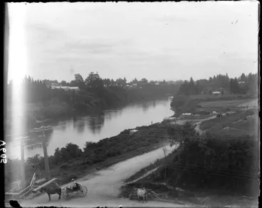
On eastern bank, 'Moule's Redoubt' was built on former Tararahi Pā near present-day Victoria Bridge (View: Former site)
Waikato River near Hamilton, 1905
Auckland Libraries
Settlement named "Hamilton"; land surveyed & land grants allocated, 1864
In August 1864, Colonel William Moule, the commander of the 4th Waikato Regiment, named the new settlement "Hamilton". The name chosen was in honour of Captain James Fane Charles Hamilton of the Naval Brigade, who died in action at Gate Pā on 20 April 1864.
The land on Hamilton's western bank and its eastern bank was surveyed and allotments of land allocated. Each militiaman was entitled to a 1-acre town allotment for their home and a 50-acre rural plot for farming. To receive the freehold titles of their allotted land, they had to remain in Hamilton for three years.
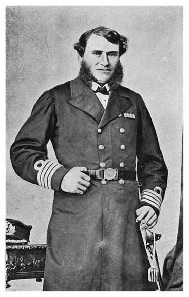
In Aug 1864, Col Moule named the town "Hamilton" after Cpt John Hamilton who died at Battle of Gate Pā on 20 April 1864
Captain John Fane Hamilton (H.M.S ESK). — Killed in the assault on the Gate Pa, 1864. (See pages 125, 286.)
Victoria University of Wellington
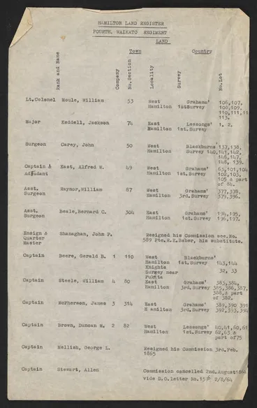
The land at Hamilton West & East was surveyed & each militiaman was entitled to: Town (c.1 acre) & Country (c.50 acres)
Hamilton Land Register
Hamilton City Libraries
On Hamilton West survey, Garden Place was designated as a road
On the Hamilton West (SO 144) survey by William Blackburn, Garden Place was designated as a road.
In Hamilton West, cottages began to be erected and wheat, vegetable gardens and trees were planted on the nearby Hamilton Hill. A school was also built at the Hamilton West Redoubt for the militia settlers' children.

On the Hamilton West (SO 144) survey by William Blackburn, Garden Place was designated as a road
Hamilton West, surveyed by W. Blackburn.
Auckland Libraries

In Hamilton West, settlers began building cottages & a school; & planted wheat, vegetables & trees on Hamilton Hill
Backhouse, John Philemon, 1843-1908 :Military settler's cottage, Hamilton. [1865-1900]
Alexander Turnbull Library
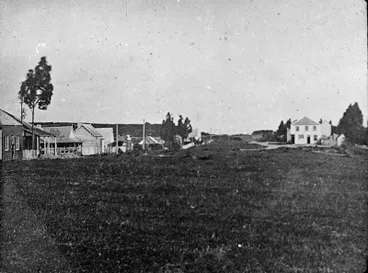
c.1865: At top of Grantham St lay Victoria St: Hamilton Hotel on right & Vialou's manufactory on left
Hamilton West
Hamilton City Libraries
Great South Road from Auckland reached Hamilton in 1867
Work on the Great South Road had begun in Auckland in 1843 and reached Drury in 1859. A bridle track was then built as far as Ngāruawahia on the eastern bank of the Waikato River. Following the Taranaki Wars, Governor Grey ordered British troops to widen and extend the road from Drury into the Waikato prior to the British invasion to suppress the Kīngitanga (Māori King movement). After the Waikato War ended in April 1864, the construction of the road through the Waikato continued and reached Hamilton during 1867. From being a military route, the Great South Road aided European settlement, linking Auckland to the confiscated lands of the Waikato region under the New Zealand Settlements Act 1863.

During 1867, the Great South Road reached Hamilton after construction first started in Auckland in 1843
Making Great South Road, Auckland, New Zealand
Museum of New Zealand Te Papa Tongarewa
Ancestral remains of Ngāti Wairere exhumed from Hill & other locations, 1866-1876
Following the arrival of the settlers, during 1866-1876 the ancestral remains of Ngāti Wairere who were buried at various localities on the hill and other places in Hamilton were exhumed. The reburials were organised by Hakopa Te Waharoa (1820-1877) and his son Te Puke Waharoa (c.1834- 1895) who led the traditional rites and rituals of the uhunga (uplifting of ancestral remains). On 28 October, 1875, the Māori Land Court granted Komakorau 146 to Hakopa.
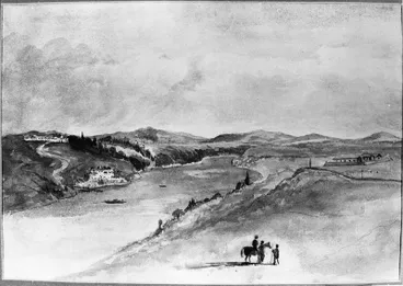
During 1866-1876, the ancestral remains of Ngāti Wairere buried on the Hamilton Hill and elsewhere were exhumed
Hamilton - W/Col. W Fox
Hamilton City Libraries
4th Militia disbanded and Armed Constabulary occupied the Redoubts, 1867
With the passage of the Armed Constabulary Act on 10 October 1867, the Waikato Militia was disbanded. The newly formed Armed Constabulary took over the policing of the region and occupied the Hamilton West Redoubt and the Moule's Redoubt.
In 1868, the gunboats were taken over by the Waikato Steam Navigation Company (WSNC) to provide for freight and passenger services between Port Waikato, Huntly, Ngaruawahia, Hamilton, and Cambridge. A new wharf was built on the Hamilton East bank in 1871.
On 10 October, 1867, the Armed Constabulary Act was passed which replaced the militia throughout NZ
Armed Constabulary 1867 No.37 [electronic resource].
National Library of New Zealand
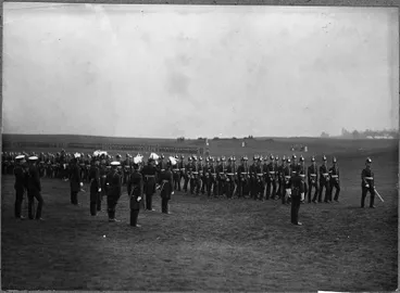
The 4th Militia were disbanded & the Armed Constabulary occupied the Hamilton West Redoubt & Moule's Redoubt until 1877
Armed constabulary on parade
Hamilton City Libraries
In 1868, the gunboats were taken over by the Waikato Steam Navigation Co who built a new wharf & goods store in 1871
HAMILTON: NEW WHARF AND STORE. (Daily Southern Cross, 28 September 1871)
National Library of New Zealand
Hamilton West's population declined due to living conditions, school closure & Thames goldfields, 1868
The settlements on the western and eastern banks of the Waikato River could only be reached by canoes or ferry at the wharf, which became known as Ferrybank Landing. Subsequently, they continued to develop as two separate communities - Hamilton West and Hamilton East.
However, by 1868, Hamilton's population was described as being "...under 300 residents, the township consisting of the two redoubts, barracks, two churches, two hotels, a few stores, a blacksmith, bootmakers, and many deserted homes." (Source: Hamilton City Council: "Kirikiriroa: Hamilton's European settler history" by Alice Morris & Mark Caunter;, Oct 2021, p.5).
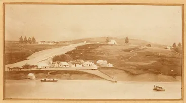
Hamilton West & East grew separately as could only be reached by canoes or ferry at the wharf, named Ferrybank Landing
Ferrybank Landing, Hamilton
Auckland Libraries
The population of Hamilton West had begun to decline due to living conditions, lack of employment, the closure of the Hamilton West School, and the attraction of the Thames goldfields. (See: Daily Southern Cross, Volume XXIV, Issue 3440, 25 July 1868, Page 4). The settlers had found the area difficult to farm. As well as cultivated land by the Waikato River and on the Hamilton Hill, there was also deep gullies, extensive swamp areas, and areas of kahikatea forest and native flora. There was also a lack of roading and little local employment. On receiving their freehold titles after staying for three years, some militia settlers chose to leave. During a visit to Hamilton in late May 1868, Governor Sir George Bowen had indicated that one of the new constables would be appointed as schoolmaster at Hamilton West School. However, a month later, after an appointment was made, the Defence Minister disallowed constables becoming teachers and the school closed which caused consternation amongst families.
Following the opening of the Thames goldfields, families began leaving aboard the paddlesteamer Bluenose which departed each Friday.

By mid-1868, Hamilton West's population declined & families began moving to Thames goldfields aboard the PS Bluenose
Steamer "Bluenose" on Waikato River at Hamilton
Hamilton City Libraries
Hamilton District School Committee formed to relocate the school, 1869
To address declining school attendance and a shortage of teachers in its area, the Auckland Provincial Council passed the Common Schools Ordinance 1869. The Ordinance established a Central Board of Education to fund, construct, and govern primary schools. The Auckland Province was divided into educational districts. The roles of Secretary to the Board and School Inspector were created and the framework for local school committees was established.
The Hamilton District School Committee was formed which began seeking funding to purchase land to build a new school. In October 1869, the Central Board granted 150 pounds to purchase 5 acres of land and build a schoolhouse. In the interim, the Committee agreed to accept two of three large rooms offered in the Reserve Hotel. (Papers Past: New Zealand Herald (15 Oct 1869, "Hamilton", Vol VI, Issue 1795, p.5) The Committee began researching possible locations for land to buy which required the Central Board's approval . Meanwhile, Hamilton West School reopened in temporary premises.
After Common Schools Act 1869 passed, Hamilton District School Committee formed to build a new Hamilton West School
THE COMMON SCHOOLS ACT. (FROM OUR OWN CORRESPONDENT.) Hamilton, August 3. (Daily Southern Cross, 06 August 1869)
National Library of New Zealand
Hamilton's second school opened in 1872 - the Hamilton East School which began in a former military hut near Steele Park (originally known as Sydney Square as members of the 4th Waikato militia had enlisted from Sydney). The following year, the school moved to the Hamilton Hall on Clyde Street. Later in September 1877, it relocated to its current location on the corner of Grey and Dawson Streets near Moule's Redoubt.
In 1872, Hamilton's second school opened in Hamilton East following the appointment of a School Committee
HAMILTON: MEETING OF SCHOOL COMMITTEE. (Daily Southern Cross, 13 March 1872)
National Library of New Zealand
Hamilton West and East administered by separate Highway Boards, 1871
During the late 1860s, the Auckland Provincial Government passed legislation that allowed the region to be divided into Highway Township Districts. The Districts were administered by elected boards which oversaw land settlement, rates, and public works, including roading and infrastructure. The Hamilton Highway District Board (Hamilton West) formed in 1871, followed by the Kirikiriroa Highway District Board (Hamilton East). Roads began to be formed in August 1871. However, the main transport for goods and supplies continued to be along the Waikato River.

In 1871, Hamilton West & East were separate towns known as Highway Township Districts run by separate Highway Boards
Hamilton West
Manatū Taonga, the Ministry for Culture and Heritage
Hamilton West was run by the Hamilton Highway District Board & Hamilton East by the Kirikiriroa Highway District Board
Hamilton West Township Highway Board minutes
Hamilton City Libraries
Homes and businesses continued being developed near and on Hamilton Hill
The main business district developed on the western bank ot the bottom of Grantham Street near the Ferrybank wharf. The stores began stretching up to the corner of Grantham and Victoria Streets. The Hamilton Hotel was built in 1865 on Victoria Street and was a social gathering place for the militia.
Farming of crops continued to be developed on the nearby Hamilton Hill with the traditional kūmara and fern crops replaced by maize, potato, cabbages, corn, pumpkin, tobacco, peach trees, and apple trees. Stock was also raised on outlying areas.
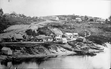
Hamilton West continued to be developed around Grantham St & uphill to Victoria St, & on the Hamilton Hil
Ferrybank landing late 1860s/early 1870s
Hamilton City Libraries

The Hamilton Hotel (on right) which was built in 1865 continued to be a social gathering place (Image: 1870s)
Victoria Street c. 1870
Hamilton City Libraries

c.1871, Anglican Church was built at south end of Victoria St after 1st church burnt down when nearly completed in 1867
Settler's cottages & Anglican Church
Hamilton City Libraries
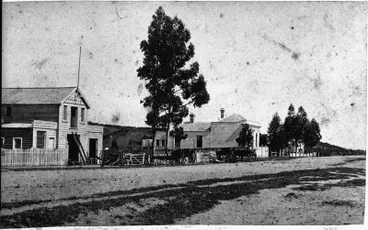
In 1872, Isaac Vialou built his house & coachworks opposite the Hamilton Hotel. The Hamilton Hill is seen in background.
Vialou's carriage factory
Hamilton City Libraries
Hamilton West School relocated to top of Hamilton Hill, 1876
After researching possible locations for siting the Hamilton West School, the School Committee received approval from the Central Board for land to be purchased on top of the Hamilton Hill. A school building was erected and the school was relocated during 1876 near where Wintec now stands.
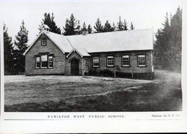
In 1876, after occupying temporary premises, the school was relocated to top of Hamilton Hill where Wintec now stands
Photograph – Hamilton West Public School
Waikato Museum Te Whare Taonga o Waikato
4. Provincial government replaced with County & Borough Councils, 1876-1877
Waikato County Council formed 1 Nov 1876
By 1868, the number of provinces had increased from six to nine, and the demand for centralised government increased. The Abolition of Provinces Act 1875 came into effect in November 1875 whereby the provincial governments were dissolved and became "provincial districts" with no administrative function.
The Counties Act 1876 divided rural areas into 63 counties which operated alongside existing Road Boards. The rural lands surrounding Hamilton were officially designated under the Waikato County Council which formed on 1 November 1876. it was responsible for rural infrastructure, including the construction and maintenance of local roads, footpaths, bridges, drainage, clearing land, pest and weed control, and levying rates.
In Nov 1875, under Abolition of Provinces Act 1875, provincial governments dissolved & became "provincial districts"
21. Abolition of Provinces Act 1875
The University of Auckland Library
The Counties Act 1876 divided rural areas into 63 counties, including the Waikato County Council which formed on 1 Nov
47. Counties Act 1876
The University of Auckland Library
Constabulary relocated from Hamilton redoubts to Cambridge & Pirongia, 1877
Following the abolition of provincial governments in 1876, provincial police forces and the Armed Constabulary were consolidated into the New Zealand Constabulary Force. The new force had two main divisions – the Policing Branch which dealt with civil law enforcement and the Reserve Division (later the Field Force), which continued to exercise armed military surveillance in case of issues arrising between settlers and iwi.
During 1877, the Constabulary ceased occupying the Hamilton West Redoubt and Moule's Redoubt in Hamilton East when two regional divisions were formed by Lieutenant-Colonel William Moule. The No. 4 Division under Moule's command based it's headquarters at Cambridge; and the No.5 Division under Major von Tempsky's command became based at the Alexandra Redoubt on Piquet Hill in Pirongia.
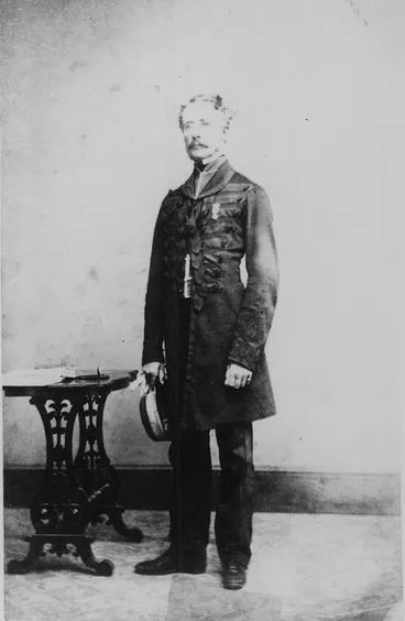
During 1877, Lt. Col. Moule formed the Hamilton Constabulary into 2 regional divisions located in Cambridge & Pirongia
Colonel Moule
Te Awamutu Museum
Hamilton Borough Council constituted on 24 Dec 1877
Under the Municipal Corporations Act 1876, the Borough of Hamilton was officially constituted on 24 December 1877 by amalgamating the two separate District Boards - Hamilton East and Hamilton West. Hamilton had a population of 1,245 and an area of 752 hectares. The Hamilton Borough Council initially met in the Hamilton Courthouse which had opened on the corner of Collingwood Street and Victoria Street on 1 March 1878. After completing the modification of two militia huts with a facade, the Hamilton Borough Council opened its Borough Chambers in April 1878 on Victoria Street opposite Garden Place.
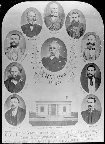
On 24 Dec 1877, the Borough of Hamilton was constituted under the Municipal Corporations Act 1876
Hamilton Borough Council and Borough Offices
Hamilton City Libraries
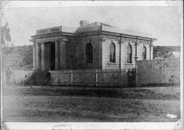
Meetings were initially held at Hamilton Courthouse which opened 1 March 1878 on the former Hamilton West Redoubt
Hamilton Courthouse
Hamilton City Libraries

In April 1878, Hamilton Borough Council Chambers opened on Victoria St opposite Garden Place in 2 converted miliia huts
First Hamilton Borough Council Chambers
Hamilton City Libraries
Auckland to Hamilton rail line: Stations at Frankton (1877) & central Hamilton (1879)
Hamilton's population and economic prosperity increased after the North Island Main Trunk Line was extended from Auckland to Hamilton.
On 19 December 1877, the Frankton Junction (later called Frankton Railway Station) opened.
In 1879, the rail line was extended from Frankton into central Hamilton on the flat land near the edge of the northern slope of Hamilton Hill. The rail track ran parallel in-between Ward Street and Bryce Street and stopped before reaching Victoria Street. A small railway station building was constructed near the corner of Ward and Selkirk Street (which ran north-to-south on the far left of Victoria Street and terminated at the railway yards), and opened on 20 October 1879.
On 1 October 1884, the eastern branch line to Morrinsville opened. The rail line was extended over Victoria Street to the newly-built Claudelands Bridge on the Waikato River and travelled through Hamilton East / Ruakura to Morrinsville.
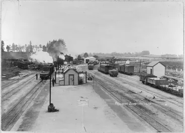
On 19 Dec 1877, the Frankton Junction opened when the North Ialand Main Trunk Line reached Hamilton from Auckland
"Frankton Junction"
Hamilton City Libraries

In 1879, the line was extended to central Hamilton between Ward & Bryce Sts on flat land near the Hill's northern slope
Passenger train at Hamilton railway station
Hamilton City Libraries

On 1 Oct 1884, the line also operated eastwards across Victoria St & the new Claudelands Bridge to Morrinsville
Hamilton Railway Bridge
Hamilton City Libraries
Union Bridge to unite Hamilton West & Hamilton East opended Nov 1879
The Town Boards had amalgamated initially to secure Government funding to build a connecting bridge. The outcome was a wooden traffic bridge being built which opened in November 1879 and was formally called the "Union Bridge".

To unite Hamilton East & Hamilton West, construction started on the wooden Union Bridge which opened in Nov 1879
A view of Hamilton showing the first traffic bridge
Alexander Turnbull Library
Ritual to remove the tapu on the Hamilton Hill, July 1881
In July 1881, Ngāti Koura tohunga (high priest) Te Ao Katoa was thought to have visited with King Tawhiao and performed an ancient ritual to remove the tapu on the Hamilton Hill. The ritual was to ensure that the Mauri of the Hill would no longer be desecrated by Pākehā walking on it, farming and developing housing. [Source: Wintec: A history of the land on which our city campus sits (pdf)]

In July 1881, King Tawhiao visited with Ngāti Koura tohunga Te Ao Katoa who was thought to have lifted tapu on the Hill
Tawhiao, Maori King
Museum of New Zealand Te Papa Tongarewa
Commercial centre moved to Victoria St along the frontage of Hamilton Hill
With the arrival of more colonists, the settlement of Hamilton grew steadily. By the mid-1870s, the development of improved road access, the introduction of the railway and the construction of the Claudelands Bridge midway along Victoria Street drew businesses and homeowners to move from Grantham Street. Shops and commercial buildings began to open along Victoria Street and its intersecting streets on the flat land to the south of Hamilton Hill and to the north of Hamilton Hill where the Hamilton Railway station lay. Businessess also began to change owners, such as the Hamilton Hotel which was taken over in 1876 by Richard and Sarah Gwynne and became known as Gwynne's Hotel. They expanded the building, including adding 18 bedrooms, a croquet lawn and stabling for 25 horses.

1880: South on Victoria St: Commercial Hotel (built 1876); Collingwood St intersection; London House & St Peter's Hall
Commercial Hotel, Victoria Street
Hamilton City Libraries

c.1880s: View along Victoria St with Hamilton Hotel (Gywnne's) in distance & Post Office to right (obscured by trees)
Victoria Street
Hamilton City Libraries
Settler farming and housing on Hamilton Hill, 1890s - 1930s
Farming land on the Hamilton Hill began to be purchased for housing. Amongst the first houses built on the hill by the early 1900s, were two by carpenter Joseph Frear. He'd purchased a piece of land on the northen slope that was near Garden Place as it had been designated as a road on the Hamilton West (SO 144) 1864 survey by William Blackburn. Frear had been a former Borough Councillor from 1884-86 and 1888-89. He married Sarah in 1889 and they raised their family in one of the homes.

The earliest houses built on Hamilton Hill included carpenter Joseph Frear's home on land he'd purchased (Image: c.1890)
Frear House
Hamilton City Libraries
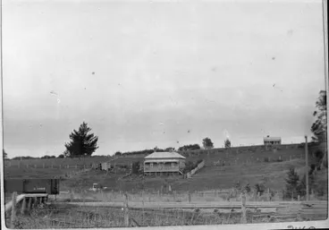
Frear had chosen land on the northern slope facing Garden Place as it was designated as a road (Image: c.1900)
Frear Home
Hamilton City Libraries

Frear, a former Borough Councillor (1885-85 & 1887-89), had married Sarah in 1889. (See family on verandah)
Frear Home
Hamilton City Libraries

Frear, his wife Sarah, & children had a vegetable garden, orchard and beehives
Frear House & garden
Hamilton City Libraries

c.1897, Dr Brewis & wife Mary built their home on the lower slopes of Hamilton Hill, overlooking Victoria St
Brewis Home
Hamilton City Libraries

Brewis' home was named 'Jesmond' after his home town of Jesmond Dene near Newcastle upon Tyne, England
Ladies and children in one-horse buggy.
Hamilton City Libraries


c.1930s: Houses on left side of Hill, with first where Alexandra St is now & third on south side of where Caro St is now
Houses on Garden Place hill
Hamilton City Libraries

1938: The houses lie halfway up the Hill between Armstrong Motors (Ford) & the old Hamilton West School in the distance
Garden Place Hill houses
Hamilton City Libraries

View from Ward Street of Hamilton Hill with Devcich house in background
Devcich house, Garden Place
Hamilton City Libraries
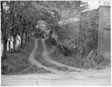
c.1938: Entrance to Devcich home on Hamilton Hill near present-day Garden Place
Entrance to Devcich home on Garden Place hill
Hamilton City Libraries

c.1938: View from Victoria Street: Women walk along footpath at foot of Hill and across 'Garden Place Road' to the left
Garden Place hill
Hamilton City Libraries
5. View atop Hamilton Hill
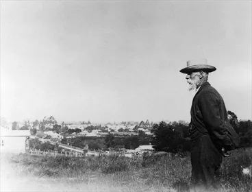
c.1900s: Joseph Fear surveying view atop Hamilton Hill where he'd purchased land on northern slope near Garden Place
Joseph Frear surveys the growing township of Hamilton, which he literally helped to build
Manatū Taonga, the Ministry for Culture and Heritage
Looking along southern slopes

c.1880: View from Hamilton Hill looking southwards across Collingwood Street to Thackeray Street
"Lake hill"
Hamilton City Libraries
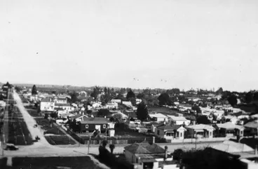
c.1920: Hamilton Hill - looking southwest across Collingwood Street. Anglesea St extends south from Collingwood St.
Aerial view of Hamilton
Hamilton City Libraries
Looking along northern slopes
Horse Bazaar building and salesyard, and railway line:
At the bottom of the Hill's northern slopes, the flat land was divided by Ward Street which ran at right angles to Victoria Street.
On the northern side of Ward Street was a block of land on which stood Hamilton's Horse Bazaar and saleyards. Both faced the branch of the railway line that ran from Frankton eastwards over Victoria Street and the Claudelands Bridge to Morrinsville.

c.1910s: Looking northwards to Ward St, Horse Bazaar (larger building on rear right) & rail line on the far side
Horse bazaar and Frear's beehives
Hamilton City Libraries
Previously, horse and stock auctions had been held in Hamilton since the mid-1880s in the backyard of the Commercial Hotel on the corner of Victoria and Collingwood Streets. As traffic and health issues grew, the Borough Council resited the saleyards on the Market House Reserve on the southern corner of Ward and Victoria Streets which opened on 9 May 1888. Later in January 1907, the saleyards were relocated further west to the corner of Selkirk Street (now Anglesea Street) and Ward Street. Alongside the saleyards, the Council opened the Hamilton Horse Bazaar building.
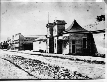
The Horse Bazaar was built in 1907 on flat land at northern edge of the Hill on Ward St (between Anglesea & Victoria St)
Hamilton Horse Bazaar
Hamilton City Libraries
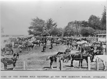
The yards & stables were used to keep horses being auctioned & were also used as a rest-stop for travellers
Horse sales at the Hamilton Horse Bazaar
Hamilton City Libraries

Rear view of the Horse Bazaar and sale yards
"Horse Bazaar. Hamilton. The largest building of its kind in the Dominion"
Hamilton City Libraries
Looking along northwestern and northeastern slopes

Looking northwest to Ward St. (On left is Hamilton Technical College which opened in 1924)
North west of CBD
Hamilton City Libraries

c.1920: Looking N.E. across Victoria St: Frear's Building (Pascoes on ground floor) on left & Carnegie Library in middle
Victoria Street from Garden Place Hill
Hamilton City Libraries
6. Garden Place Hill frontage on Victoria Street

Garden Place Hill frontage lay on left side of Victoria St (Image: 1902)
Victoria Street and Garden Place hill in 1902
Hamilton City Libraries
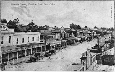
c.1908: View from Post Office to businesses on the right of Garden Place backing onto the Hill
"Victoria Street, Hamilton from Post Office"
Hamilton City Libraries

17 Feb 1908: View of opening ceremony on Garden Place frontage for the Hamilton Public Library on Victoria St
Hamilton Free Public Library
Hamilton City Libraries

The Library, funded by £2,000 grant from Scottish-US philanthropist Andrew Carnegie, was also known as Carnegie Library
Hamilton's "Free Public Library"
Hamilton City Libraries
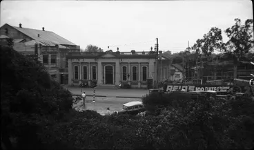
Another view of the Public Library from Garden Place Hill showing the proximity of the Hill to Victoria St (1939)
Victoria Street
Hamilton City Libraries
Council's proposal to close off front of Garden Place rejected by ratepayers, 1908
By 1906, property values had begun to increase in Hamilton. The Hamilton Borough Council proposed that Garden Place's frontage on Victoria Street be leased for commercial buildings and erected a fence. Ratepayers, including former Borough Councillor Jospeh Frear, objected to Garden Place being closed off and Frear pulled down the fence. At a public meeting held in November 1908, the Council's proposal was rejected by a large majority of ratepayers.
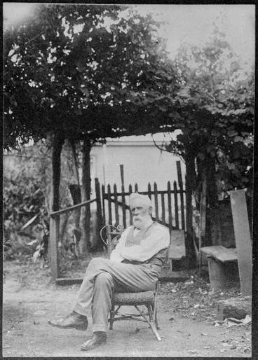
In 1908, Council's proposal to lease Victoria St frontage rejected by ratepayers including Frear who pulled fence down
Mr Joseph Frear
Hamilton City Libraries
"The Rosery' developed at Garden Place by Hamilton Beautifying Society, 1914
In 1914, 'The Rosery' on the Victoria Street frontage of Garden Place Hill was completed by the Hamilton Beautifying Society, which had formed in 1912. See article about 'The Rosery' in Papers Past: Waikato Argus (8 May 1914), "Hamilton Beautifying Society", (Vol XXXV, Issue 5603, p.3)

1914: 'The Rosery' on Victoria St frontage of Garden Place Hill was built by Hamilton Beautifying Society (formed 1912)
" The Rosery. Hamilton "
Hamilton City Libraries
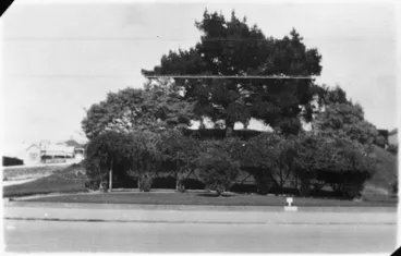
1924: Looking across Victoria St to Garden Place rosery. A house on the south side of hill is visible on left.
Garden Place, Hamilton
Hamilton City Libraries
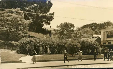
Postcard of 'The Rosery' at Garden Place, Hamilton (No date)
Postcard/Photograph – Garden Place Hamilton
Waikato Museum Te Whare Taonga o Waikato
Buildings developed near Garden Place on Victoria St

In 1913, Union Bank of Australia opened followed by Commercial Bank of Australia & Bank of Australasia in 1920s
Victoria Street
Hamilton City Libraries

In 1916, A 2-storey building was constructed by Jospeh Frear on the right-hand corner of Victoria St & Garden Place
"Garden Place, Hamilton. N.Z."
Hamilton City Libraries
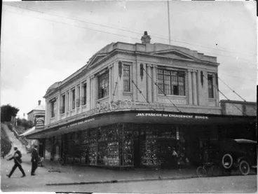
Known as Frear's Buildings, the main tenant was the jewellery firm of James Pascoe
Frears Building
Hamilton City Libraries

In 1929, James Pascoe purchased Frear's Buildings, which later became known as Pascoe's Buildings
Pascoe's corner' Victoria Street
Hamilton City Libraries
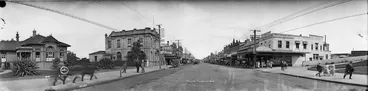
1923: Courthouse (on left), Union Bank of Australasia (opened 1913) & United Insurance Co Ltd (by Garden Place)
Victoria Street, Hamilton
Alexander Turnbull Library
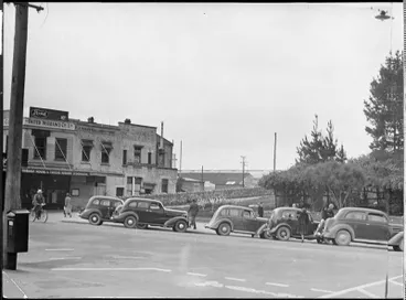
In 1923, the United Insurance Co located its office on Victoria St near Garden Place Hill
Garden Place Hill
Hamilton City Libraries
7. Public debate on keeping or removing the Hill or building a tunnel, 1920s - 1930s
As the 10-metre high Hill separated the commercial centre of Hamilton, business owners began agitating for its removal.

In 1920s, business owners began agitating for removal of 10 metre high Hill as it separated the commercial centre
Suggested removal of garden place hill, in the borough of Hamilton, Auckland province, causes a keen controversy
Auckland Libraries
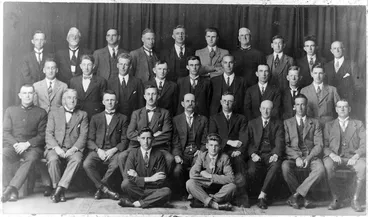
Council held public meetings during which the debate included removing the whole Hill
Hamilton Council Staff 1927
Hamilton City Libraries
In 1925, the newly appointed Borough Engineer, Rupert Worley, presented a plan to the Hamilton Borough Council to flatten the hill at Garden Place to unify the north and south ends of Hamilton's business district. Levelling the hill would improve the flow between Anglesea St and Ward St and create more carparking spaces. (Worley remained as Borough Engineer until 1942. Hamilton's Worley Street, which ran between Alexandra Street and Anglesea Street parallel to Caro Street near Garden Place, was named after him in 1940. When Worley Street was built over in the mid-1980s to make way for the Municipal Offices building, the northern end of the intersecting Alexandra Street between Ward Street and Caro Street was subsequently renamed as Worley Place.)
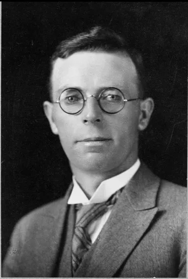
In 1925, Borough Engineer Rupert Worley presented a plan to flatten the hill at Garden Place to improve access & parking
Rupert Worley
Hamilton City Libraries
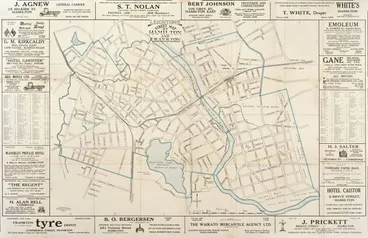
Worley stated flattening would improve flow between Anglesea St & Ward St, & create more carparking spaces (Map 1920)
Leightons street map of Hamilton and Frankton
Auckland Libraries
Public meetings were held during which the debates included whether the rest of the hill should also be removed. An alternative proposal of building a tunnel was then put forward by Worley to improve the traffic flow rather tham remove the hill completely.
Proponents against the removal of the hill included the Garden Place Preservation Society who wanted to retain Garden Place Hill as they regarded it as a significant natural and cultural landmark. They also objected to paving over the area for commercial expansion. Local stargazers also wanted the hill to be retained so that an astronomical observatory could be placed on top and they formed the Hamilton Astronomical Society in 1933.
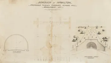
As an alternative option for improving traffic flow, Worley proposed having a road tunnel which was also debated
Architectural plans – Anglesea Street tunnel
Waikato Museum Te Whare Taonga o Waikato

Hamilton Beautifying Society wanted the hill retained as they regarded it as a significant natural & cultural landmark
Hamilton Beautifying Society records 1921-1952
Hamilton City Libraries
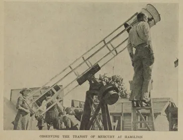
Stargazers wanted to keep the hill to place an observatory on top & formed the Hamilton Astronomical Society in 1933
Observing the Transit of Mercury at Hamilton
Auckland Libraries
The outcome of the debates was the Hamilton Borough Council deciding to:
Stage 1. Make a cutting through the ridge of the hill to extend Anglesea Street to join Ward Street which bordered the block of land occupied by the railway line. The eastern line from Frankton to central Hamilton had opened in 1879; then was extended across Victoria Street and the Claudelands Bridge to Morrinsville in 1884. On the far side of the railway line, directly opposite Anglesea Street was Selkirik Street. (When the railway line was lowered underground across central Hamilton in the 1960s, a connecting road was built between Anglesea Street and Selkirk Street which was renamed Anglesea Street.)
Stage 2: Remove the hill between Anglesea Street and Garden Place and sell or lease the land which required Parliamentary approval (granted in 1935).
The story of Garden Place has been recounted in the stage play "One Hill of a Fight" (2017) written by Michael Spitzer which was performed at the Meteor Theatre in Hamilton.
History of hill's removal is retold in Michael Switzer's play. (RNZ interviews writer & producer, 7 May 2017: 12:19 min)
One Hill of a Fight
Radio New Zealand
8. Cutting through the Hill's ridge to form Anglesea Street: 1931
A cutting was made through the ridge to allow the formation of Anglesea Street. The cutting to link Anglesea Street to Ward Street was reinforced by a concrete wall shortly after. The Hamilton Technical College continued to occupy the land above the wall on its lower slope.

Anglesea Street cutting
Hamilton City Libraries

Looking northeast along Anglesea St, with wall on left beneath the Hamilton Technical College, 1935
Anglesea Street
Hamilton City Libraries

These houses on Collingwood St & what is now Caro St remained after the Anglesea Street cutting was made
Houses on Garden Place hill c. 1939
Hamilton City Libraries

Steps led up from Anglesea St cutting to the houses on south-west corner of Garden Place Hill (Image: 1939)
Garden Place Hill 1939
Hamilton City Libraries
9. Parliamentary approval to remove the Hill granted Oct 1935
Parliament passed the Hamilton Borough Council Empowering Act 1935 giving the Hamilton Borough Council permission to proceed with removing the hill and selling or leasing the land, which became law on 26 October 1935. As the Act had stipulated the hill was to removed within two years, the time-frame was amended to four years on 11 December 1937 in the Hamilton Borough Council Empowering Amendment Act 1937 (Local) (1 GEO VI 1937 No 15)
Parliament passed the Hamilton Borough Council Empowering Act 1935 (26 Oct 1935) to remove the hill & sell & lease land
14 Hamilton Borough Council Empowering Act 1935
The University of Auckland Library
Parliament extended the time-frame from 2 to 4 years, in the Amendment Act 1937 (assented 11 Dec 1937)
15 Hamilton Borough Council Empowering Amendment Act 1937
The University of Auckland Library
A. Relocation of houses, 1938 - 1940

House in Palmerston Street
Hamilton City Libraries

House at foot of Garden Place
Hamilton City Libraries

Removal of Garden Place Hill home
Hamilton City Libraries
B. Excavations of Hill get underway
The ridge of Anglesea Street was bulldozed to flatten the area for the development of Garden Place and the central CBD. A ritual was performed to remove tapu from the hill before the hill was excavated.
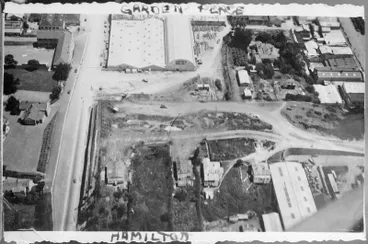
Jan 1939: View of Garden Place with Anglesea St on left, Winter Show buildings at top & Victoria St on top right
Hamilton central city
Hamilton City Libraries
Excavations begin near the Anglesea Street cutting

On the left of the Anglesea cutting are the beginnings of the removal of Garden Place Hill in 1939
Anglesea Street Cutting
Hamilton City Libraries
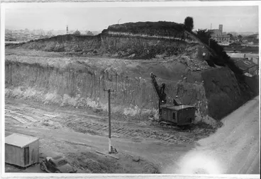
View looking near south east along Anglesea St - the excavator is at western end of the hill
Excavation of Garden Place hill.
Hamilton City Libraries

Excavation of Garden Place hill.
Hamilton City Libraries
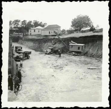

Excavation of Garden Place hill
Hamilton City Libraries
The bulldozed soil and clay was trucked away and used to fill various gullies and other low-lying areas around Hamilton, including: Waitawhiriwhiri gully in Hamilton West; Maeroa Bridge (to create an embankment); Lake Rotoroa (to build up land around its margins and to form parks); and Rugby Park (to cover its fields which were used by the Home Guard and as a military training base during WWII). The soil was also used at Frankton Raiway Station, which had been built in a drained peat basin, to provide a more solid surface for rail yards; and the building of prefabricated State housing nearby.
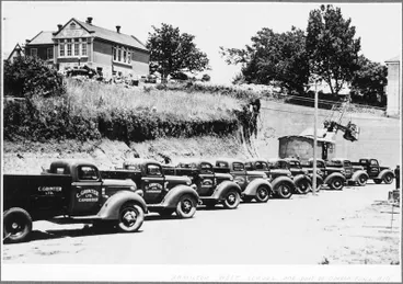
Jan 1939: Fleet of Ford trucks to transport the excavated soil which was used to fill gullies & other low-lying areas
Fleet of trucks at Garden Place Hill.
Hamilton City Libraries

Excavation of Garden Place Hill
Hamilton City Libraries
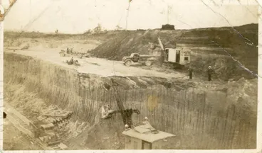
Two diggers working on removal of hill & small dump trucks transport the removed soil
Excavations of Garden Place Hill
Hamilton City Libraries
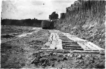
Removal of Garden Place Hill
Hamilton City Libraries
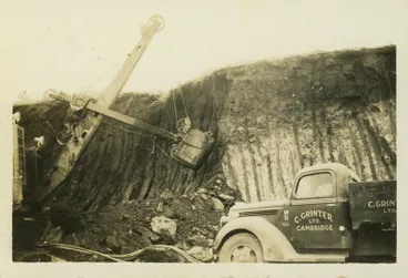
Excavating Garden Place Hill
Hamilton City Libraries
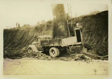
Excavating Garden Place Hill
Hamilton City Libraries
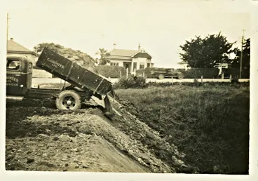
Garden Place Hill soil being dumped to fill a gully
Dumping soil from Garden Place Hill
Hamilton City Libraries
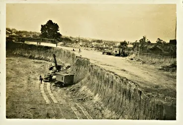
Excavating Garden Place Hill
Hamilton City Libraries
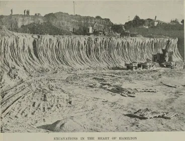

May 1939
Transformation in Hamilton: changed appearance in the heart of the town as Garden Place Hill disappears
Auckland Libraries
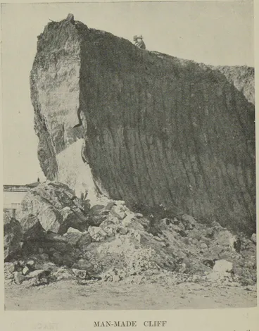
May 1939: Photo showing the depth of the excavation needing to remove the hill
Man-made cliff
Auckland Libraries

The front of the hill removed alongside the Garden Motors property exposing brickwork
Garden Place hill excavations
Hamilton City Libraries

The ridge by the Anglesea St embarkment almost cleared
Garden Place mostly cleared
Hamilton City Libraries

Jan 1939: View of completed Anglesea cutting & the remaining Garden Place Hill behind Winter Show's 3 white buildings
Central Hamilton
Hamilton City Libraries
Excavations between Anglesea & Victoria Streets
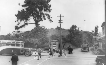
Late Jan/Feb 1939: One tree still to be felled before excavations begin by Victoria St
Garden Place Hill
Hamilton City Libraries
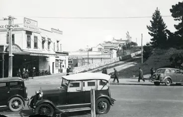
1939: Looking across Victoria St to the residents' road up Garden Place Hll with the "Rosery' to the right
Victoria Street and Garden Place
Hamilton City Libraries

Garden Place from Victoria St. A taxi stand is on the right beside the taxi phone kiosk.
Garden Place
Hamilton City Libraries

Taxi phone kiosk has adverts for Garden Place Motors, Gaiety Skating Rink, & James Pascoe Ltd building on corner
Garden Place hill
Hamilton City Libraries

Next door on left of James Pascoe was Garden Motors (which was later replaced by Woolworths, DEKA, & 'Silver Surfers')
Garden Motors
Hamilton City Libraries

1939: Garden Place Hill being removed between Victoria & Anglesea Sts with Bledisloe Hall top right
Garden Place, Hamilton
Alexander Turnbull Library
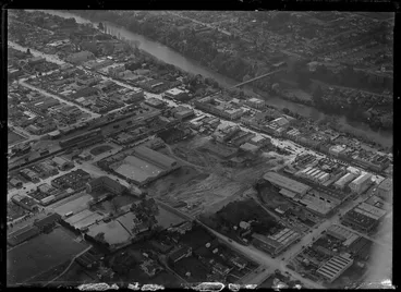
1939: View of Garden Place Hill being removed between Anglesea & Alexandra Sts (Winter Show buildings near top right)
Garden Place, Hamilton
Alexander Turnbull Library

View of Garden Place being cleared from Anglesea St across Alexandra St to Victoria St
Removal of Garden Place Hill
Hamilton City Libraries
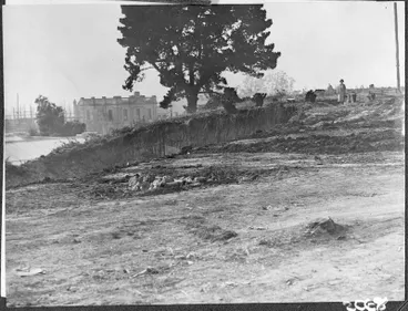
South-east top of the hill being removed. New CPO under construction on left.
Garden Place hill excavation
Hamilton City Libraries

c.1939: Site on Victoria St opposite Garden Place being excavated for new Chief Post office to right of Public Library
Excavating Post Office site in Victoria Street
Hamilton City Libraries
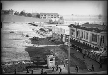
View of Garden Place stretching from Victoria St to Anglesea St's wall, with Hamilton Technical School at top right
Garden Place
Hamilton City Libraries

View of Bledisloe Hall with Winter Show fairground. Outcrop of hill seen in background.
Waikato Winter Show during removal of Garden Place Hill
Hamilton City Libraries

Garden Place mostly cleared
Hamilton City Libraries
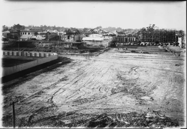
View atop the hill looking over Garden Place to Victoria St with Public Library at rear & CPO under construction
Clearing Garden Place
Hamilton City Libraries
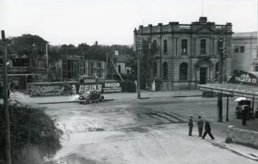
1939: View from Garden Place of Post Office under construction on Victoria St
Post Office under construction
Hamilton City Libraries
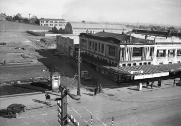
c.1939: Pascoes is on right in former Frear's Buildings. Curved roof behind is Winter Show's Bledisloe Hall.
Garden Place
Hamilton City Libraries
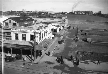
10. Creation of Garden Place with parking spaces
The transformation of the centre of Hamilton City's shopping area into a parking space is captured in these aerial and street-level photos. The outside areas of Garden Place were divided into 11 sections, while the central area was set aside as car parking for 150 cars. An underground Gentlemen's toilet block was also built near Alexandra Street.
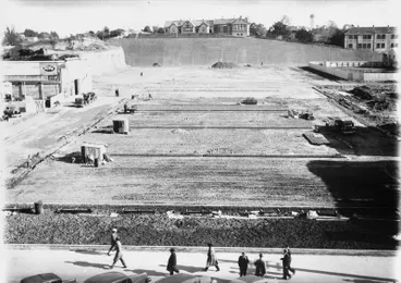
Flattened Garden Place: outside areas to be divided into sections & central area to become carpark facing Victoria St
Garden Place
Hamilton City Libraries
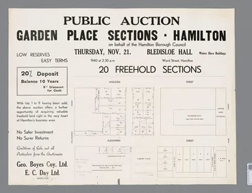
On 21 Nov 1940, auction was held by Hamilton Borough Council for freehold sections between Garden Place & Anglesea St
Garden Place Sections
Hamilton City Libraries

c.1940: Car park at front half of Garden Place near Victoria St & undergound toilets to be built along last row of cars
Garden Place
Hamilton City Libraries

25 June 1941: Parking expanded to Anglesea St & undergound Gentlemen's toilet block & Post Office are visible top left
New parking place for Hamilton motor-vehicles: accommodation in Garden Place area
Auckland Libraries
11. Garden Place during WWII
Open-air rallies held
Garden Place provided a large, open-air rallying area during World War II.

1 Jan 1941: Gathering to farewell Lord & Lady Galway who were returning to UK. (He'd been Governor- General since 1935)
Hamilton citizens' farewell to Lord and Lady Galway: His Excellency addressing the gathering in Garden Place
Auckland Libraries
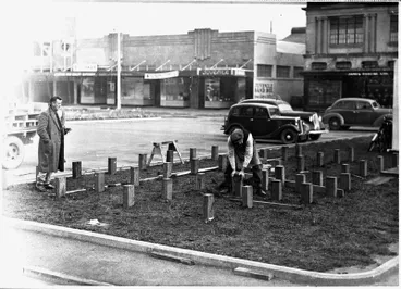
Air-raid trenches dug during 1941 & Feb 1942
During 1941, volunteers dug trenches in Garden Place which were then wood-lined, to provide protection during air-raids. The trenches were organised under the Government's Emergency Precautions Scheme (EPS). The Chief Warden of the Scheme for Hamilton was Harold Caro who was appointed Mayor in 1938. The EPS was set up by the Government as part of the home defence system. Local volunteers trained in first aid and firefighting to prepare citizens for potential air-raids and poison-gas attacks from the Japanese. The Government also distributed EPS guidebooks to households which contained instructions on actions to take during an air raid.
During an air-raid alarm test in February 1942, the number of trenches in areas of the central business area were found to be insufficient and Mayor Caro asked for volunteers to dig more trenches. Near the end of WWII, when the threat of a Japanese invasion has lessened, the trenches were filled in.

In 1941, trenches were dug for protection from potential Japanese air-raid. (In background are the underground toilets.)
Digging Trenches - Garden Place, Hamilton
Hamilton City Libraries
The trenches, which were then wood-lined, were organised under the Government's Emergency Precautions Scheme
MEETING ATTACK (Evening Post, 18 January 1941)
National Library of New Zealand
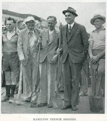
Feb 1942: Trench diggers with Mayor Caro who'd requested volunteers as an air-raid drill showed more trenches needed
Hamilton trench diggers
Auckland Libraries
Patriotic Hut suggested by Hilda Ross opened Oct 1942
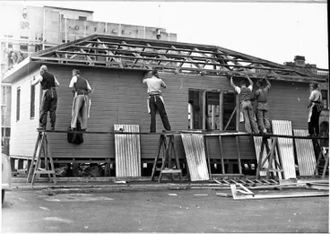
The Patriotic Hut was opened on 6 October 1942 to provide a gathering place and a dormitory for the personnel of the Armed forces resident in or on leave visiting Hamilton. The concept of the Patriotic Hut was launched by Hilda Ross who'd founded the Hamilton Women's Auxillary Volunteer Corps (WAVC) in 1939. Funding was provided by the Auckland Provincial Patriotic Council from the Fighting Services Welfare Appeal which was conducted nationally by the Y.M.C.A. and Salvation Army to raise funds for the National Patrotic Fund Board. The Hamilton Patriotic Committee appointed a sub-committee to arrange for the erection of the Patriotic Hut.

A Patriotic Hut was suggested by Hilda Ross who'd founded the Hamilton Women's Auxiliary Volunteer Corps (WAVC) in 1939
Hilda Ross
Alexander Turnbull Library
In 1942, the Patriotic Hut was built in Garden Place as a gathering place for members of Armed Forces & local community
Ellis and Burnand - Patriotic Hut, Hamilton - WWII
Hamilton City Libraries

Funding was provided by the Auckland Provincial Patriotic Council from the national Fighting Services Welfare Appeal
Ellis and Burnand - Patriotic Hut, Hamilton - WWII
Hamilton City Libraries
The work was carried out by the Waikato Associated Builders who erected an Ellis & Burnand 'Ready to Erect Cottage'. The Patriotic Hut had a floor area of c.5400 square feet. The exterior was built in rimu and the flooring of matai. A separate bakehouse building, measuring 16ft by 8ft, was erected at the rear. The facilities, which cost c.£3OOO, included the following.
The recreation room is 58ft. by 24ft., the reading and writing room 15ft. by 24ft., the dormitory 45ft. by 24ft., the dining room 40ft. by 24ft., and the kitchen and pantry 20ft. by 24ft. In addition there is a toilet room for the staff, a cloak room, ladies’ cloak room for visitors, and office, caretaker’s room, linen cupboards, showers, shaving cupboards and wash basins, cloak and baggage rooms. In the dormitory there are 20 beds, each supplied with a handy-sized locker. The dining room has accommodation for seating nearly 100 men at each sitting.
Source: Papers Past: Waikato Times (6 Oct 1942), "Patriotic Hut", (Vol. 131, Issue 21852, p.2)

An Ellis & Burnand 'Ready to Erect Cottage' was used for the Patriotic Hut & a bakehouse was built behind
Ellis and Burnand - Patriotic Hut, Hamilton - WWII
Hamilton City Libraries
The Patriotic Hut which cost c£3OOO included recreation room, reading & writing room, & dining room that could seat 100
Ellis and Burnand - Patriotic Hut, Hamilton - WWII
Hamilton City Libraries
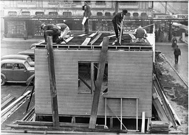
Also included were staff facilities & a 20-bed dormitory for soldiers on leave, showers, wash basins & toilets
Ellis and Burnand Patriotic Hut Hamilton WWII
Hamilton City Libraries
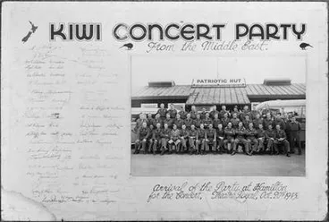
View of Patriotic Hut with wings on left & right. (Image: Visiting Kiwi Concert Party posing in front on 20 Oct 1943)
Kiwi Concert Party from the Middle East. Arrival of the Party at Hamilton for the Concert. Theatre Royal Oct. 20th 1943.
Auckland War Memorial Museum Tāmaki Paenga Hira
The Patriotic Club's operational support and recreational activities were provided by volunteers from WAVC; the local Women's Patriotic Community; and the Hamilton Branch of the YMCA which had formed in 1908. Two of WAVC's four coordinators later became Hamilton Councillors: Hilda Ross (who was the first woman to be appointed as a Hamilton Councillor in 1944; then became Deputy Mayor in 1945 and MP from 1945 - 1959); and Dorothy Blomfield (who became the second women appointed as a Hamilton Councillor from Dec 1947-1971). See article about the support provided during an event for over 2400 soldiers; Papers Past: Waikato Times (20 October 1942): Troops entertained: Busy time in Hamilton - Over 2400 in Patriotic Hut" (Vol 131, Issue 21864, p. 4)
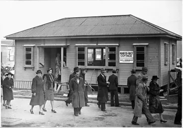
Activities were run by Women's Auxiliary Volunteer Corps (WAVC), local Women's Patriotic Committee & Hamilton YMCA
Ellis and Burnand - Patriotic Hut, Hamilton - WWII
Hamilton City Libraries
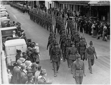
Four WAVC members oversaw canteen, clerical duties & accommodation. (Image: WAVC seen marching behind 6th Company, 1941)
6th Hamilton company NMR - parade at Hamilton for Governor Generals visit
Hamilton City Libraries
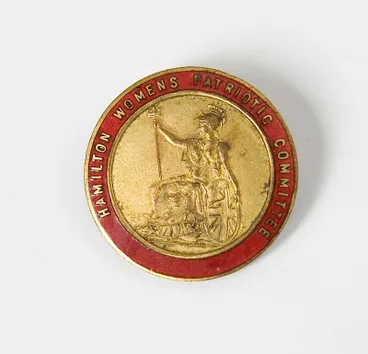
Local women's Patriotic Committee knitted clothing, organised care packages & raised funds to keep Patriotic Hut stocked
Badge – Women's Patriotic Committee, Hamilton
Waikato Museum Te Whare Taonga o Waikato
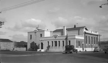
Volunteers from Hamilton branch of the YMCA managed the recreational & support services (Image: YMCA building)
YMCA building, corner of Bryce Street & Barton Street
Hamilton City Libraries

9 July 1943: Gathering in Garden Place for address by Lt-General Sir Bernard Freyberg, V.C. during his 2-week NZ tour
Thousands of citizens hear address by Lieutenant-General Sir Bernard Freyberg, V.C.
Auckland Libraries
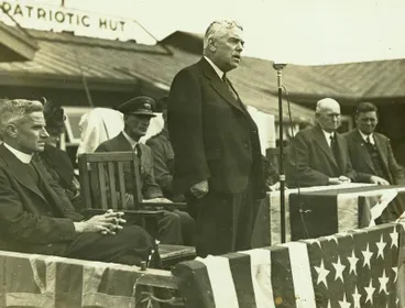
The speeches were held in front of Patriotic Hut. (Image: Minister of Finance Walter Nash)
Walter Nash addressing an (out of frame) gathering in Garden Place
Hamilton City Libraries
Patriotic Hut sold to Hamilton Combined Returned Services (Aug 1945)
In May 1944, the Hamilton Combined Returned Services (HCRS) launched a fundraising campaign to raise £25,000 to build a Memorial Club for Returned Service men and women in central Hamilton. (See: Papers Past: Waikato Times (4 May 1944), Memorial Club, Vol 194, Issue 22339, p.4)) The location eventually chosen was Garden Place and the option to purchase four sections, including the Patriotic Hut, was obtained from the Hamilton City Council in September 1944. Following further fundraising, the purchase was completed by the HCRS who took occupancy on 29 August 1945. A public meeting was held six days earlier at the Patriotic Hut to discuss the future of the new club and to appoint a committee. (See: Papers Past: Waikato Times (21 Aug 1945), Advertisements, Vol 106, Issue 22692, p.1)
Nearby, the carpark on the other side of Alexandra Street by the Municipal Offices building became a car and bus park operated by the Council. In the image below, the bus advertising includes vehicles as far away as Thames.

Patriotic Hut became Combined Returned Services Club on 29 Aug 1945. A car & bus park was sited by Municipal Offices.
Garden Place in the late 1940s
Hamilton City Libraries
Patriotic Hut building auctioned & removed to Fairfield (c.1949/1950)
On 26 July 1949, the Patriotic Club building was sold by HCRS at an auction for £2600 to the Catholic Church who intended to relocate it to Fairfield to use as a school, church and social centre. (Source: Papers Past: Te Awamutu Courier (27 July 1949), 'Local and General", Vol 79, Issue 7086, p.6). Subsequently, the Parish of St. Joseph's, Fairfield began on Sunday, 5 January, 1950: "The Parish began, then, in this building. It provided a Chapel (today the schoolroom of Standard 4 and Forms 1 and 2 and spare room), the hall and three classrooms, supper room, toilets, etc. A "flat" at the south end was furnished for the priest. " Source: SJF: St Joseph, History @ Hamilton. In September 1949, a building permit was granted to the Hamilton Combined Services to erect a larger building as a club in Hamilton.
A commemorative photo (see below) was taken by the auctioneers, C.G. Bradley Ltd, of the Patriotic Hut sited towards the rear of the carpark. The photo also shows that the Hamilton City Council had further developed Garden Place with a grassed area and pathways near the frontage on Victoria Street.
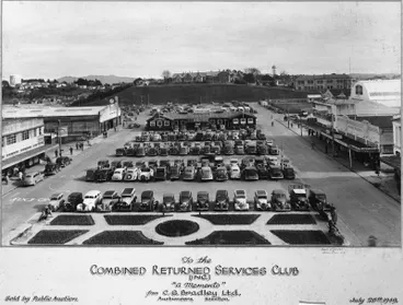
On 26 July 1949, Patriotic Hut sold to Catholic Church to form Parish of St Joseph's, Fairfield. (Image by auctioneers)
Garden Place
Hamilton City Libraries

Garden Place looking from Alexandra St to Victoria St after Patriotic Hut removed from other side of underground toilets
Garden Place c.1946/47
Hamilton City Libraries
12. Garden Place post-World War II: 1945 - 1950s
Carparking & two one-way entry & exit roads at Garden Place
On 15 August 1945 (VJ Day), the Second World War ended with the surrender of Japan. Towards the end of the war, Garden Place had resumed being used as a carpark between Victoria Street and Alexandra Street. The increasing use of buses led to the carpark on the other side of Alexandra Street near the Municipal Offices building becoming a car and bus park operated by the Hamilton City Council.
Access to the Garden Place carpark between Victoria Street and Alexandra Street was via two one-way roads travelling in opposite directions. From Victoria Street, vehicles could enter the left side of Garden Place and exit onto Alexandra Street which had 'No Entry' painted on the road. From Alexandra Street, vehicles could enter the opposite side of Garden Place and exit onto Victoria Street which also had 'No Entry' painted on the road. Parking was also sited parallel to the kerbing outside the stores fronting onto the one-way roads.
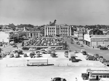
Vehicles seen entering one-way road from Alexander St (on left) & from Victoria St (on right) (Image: 1950)
Garden Place, Hamilton
Hamilton City Libraries
Queen Elizabeth II's coronation celebration, 2 June 1953
In 1953, Queen Elizabeth II's coronation on 2 June was celebrated at Garden Place.
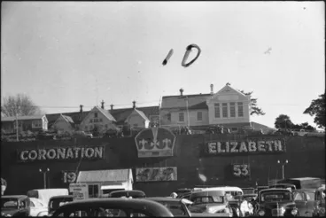
1953: Queen Elizabeth II's coronation on 2 June celebrated in Garden Place. (Decoration placed on Anglesea wall)
Council staging Garden Place
Hamilton City Libraries
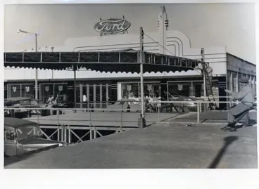
Stage being prepared at Garden Place for the coronation celebrations
Photograph – Garden Place being prepared for celebration for Queen Elizabeth II's coronation celebrations
Waikato Museum Te Whare Taonga o Waikato
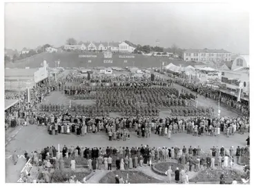
Crowd gathered at Garden Place to celebrate the coronation
Celebration of Queen Elizabeth II's Coronation, Hamilton
Waikato Museum Te Whare Taonga o Waikato
Sundial gifted by Hamilton Astronomical Society installed in Dec 1953
In December 1953, a sundial was installed by the Hamilton Council at Garden Place to coincide with Queen Elizabeth II's Royal Tour to NZ during which she would stop over in Hamilton on 30-31 December. The sundial, which had been gifted by the Hamilton Astronomical Society in 1947, was placed at the front of Garden Place near Victoria St where the Queen and her entourage would drive by en route to the Hamilton Hotel.
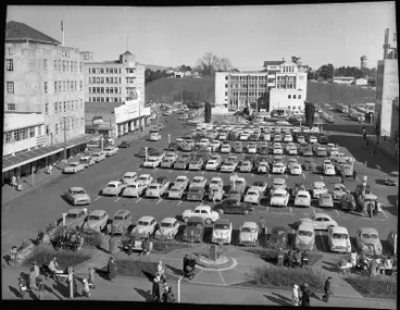
In Dec 1953, a sundial gifted by Hamilton Astronomical Society in 1947 was placed in Garden Place at front of carpark
Garden Place.
Hamilton City Libraries

Sundial was positioned near Victoria St in time for Queen Elizabeth's stay in Hamilton on 30-31 Dec during her NZ tour
Royal procession
Hamilton City Libraries
The idea of a sundial had originally been proposed In September 1936 by the Hamilton Astronomical Society's co-founder Allan Bryce as a gift to Hamilton to mark the coronation of King Edward VIII. The sundial, which was designed by Bryce, was completed in February 1937 by when King Edward had abdicated in December 1936. However, the Hamilton Council did not initially take up the offer of the sundial. After the completion of the Garden Place carpark and the end of World War II, the Hamilton Astronomical Society had reoffered the sundial which was accepted by the Hamilton Council in 1947. The decision where to place the sundial was made six years later after Queen Elizabeth II had announced plans to visit NZ in 1953.
Source: Garden History Research Foundation: "Hamilton's Garden Place sundial" by Lindsay Amner. (Sept 2025)
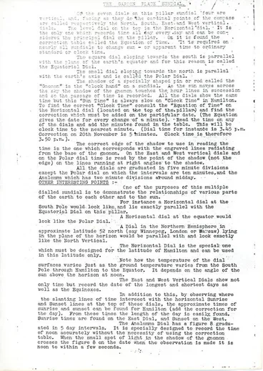
Explanatory note for the seven dials on the sundial produced by the sundial's designer Allan Bryce
The Garden Place sundial
Hamilton City Libraries
13. Buildings on perimeter of Garden Place, 1950s - 1960s
Winter Show buildings & William Paul Hall on Alexandra St by Worley St

Dec 1955: View of Garden Place with carparks between Victoria & Anglesea Sts & Winter Show buildings on middle right
Hamilton City with Victoria Street foreground and Anglesea Street beyond, Waikato Region
Alexander Turnbull Library
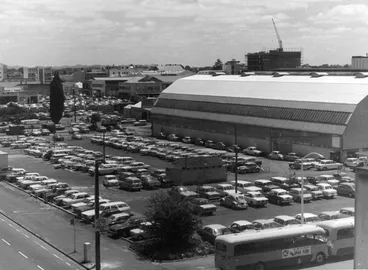
In 1956, Winter Show's carpark spaces on Alexandra St by Worley St corner were removed to build the William Paul Hall
Central city carpark
Hamilton City Libraries
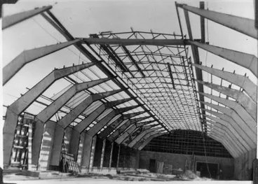
The William Paul Hall was built two storeys high and had a curved roof
Construction of William Paul Hall
Hamilton City Libraries
Garden Place on corner of Alexandra & Caro Sts

1956: New buildings on right included CML & the National Insurance Co (now Caro House) on corner of Alexandra & Caro Sts
Garden Place and Civic Square in the 1950s
Hamilton City Libraries

Dec 1956: Building being constructed on left side of Garden Place by Guardian Royal Exchange Assurance
Garden Place in the 1950s
Hamilton City Libraries
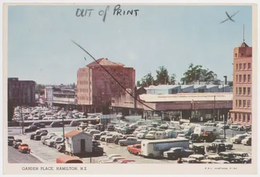
c.1958-1959: Car parks straddling both sides of Alexandra St, with Victoria St at top left & Anglesea St at bottom end
Garden Place, Hamilton
Museum of New Zealand Te Papa Tongarewa

In 1959, MLC was built to to the left of Guardian Royal Exchange Assurance & sits on corner of Garden Place/Alexandra St
Slide - Mutual Life Corporation building, Hamilton
Waikato Museum Te Whare Taonga o Waikato
Municipal Offices between Alexandra & Anglesea Sts
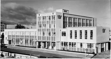
On 9 July 1960, Municipal Offices opened on Worley St.
Hamilton Municipal Offices - Caro Street
Hamilton City Libraries
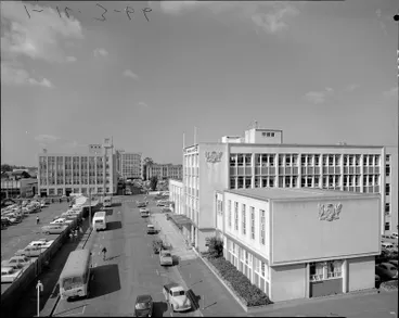
1960s: View from top of Anglesea St along Muncipal Offices on Worley St to MLC & Garden Place
Hamilton City Council municipal buildings 1960s
Hamilton City Libraries
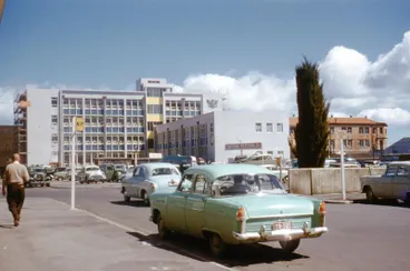
View of the rear of the Municpal Offices which faced Caro St & the side wing that faced Alexandra St & Garden Place
Garden Place & the Hamilton City Council Municipal Building
Hamilton City Libraries
Hamilton Public Library relocated to Municipal Offices building, 1960
By 1960, the Hamilton Public Library's services had expanded requiring larger premises than its Carnegie building sited on Victoria Street opposite Garden Place. In June 1960, the Library was relocated into the Council's new Municpal Offices nuilding on the other side of Garden Place on the corner of Alexandra and Worley Sts; and the old Library site sold.

In June 1960, the Hamilton Public Library was moved from it's building on Victoria St & the site was sold
Hamilton Public Library
Hamilton City Libraries

The Hamilton Public Library moved to the new Municipal Offices on Worley St
Hamilton Public Library
Hamilton City Libraries
Buildings surrounding Garden Place Square
Many of the original buildings can still be seen today, although the shops and businesses within them have changed.
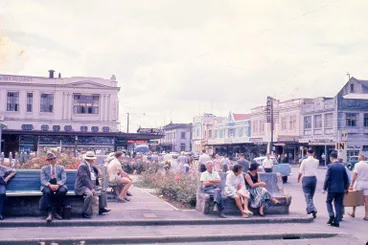
1961: Looking north along front of Garden Place on Victoria st towards James Pascoe Ltd on the left
Garden Place at Victoria Street
Hamilton City Libraries
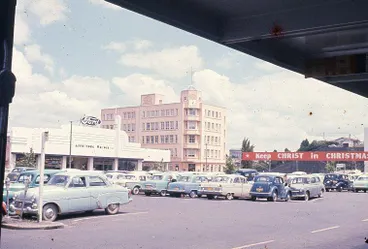
1961: View from Victoria St to Armstrong Motors on left & National Insurance Co. Ltd on corner of Alexandra & Caro Sts
Garden Place
Hamilton City Libraries
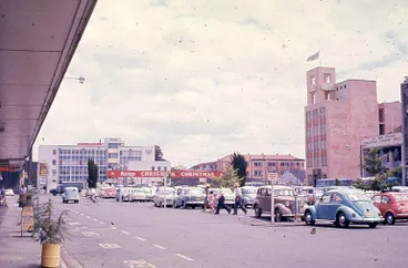
1961: View from Victoria St looking across Garden Place towards MLC on far right corner by Alexandra St
Garden Place
Hamilton City Libraries
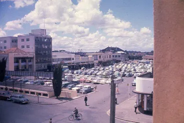
1961: View from Alexandra St looking across the undergound toilet & carparks on Garden Place to Victoria St
Garden Place
Hamilton City Libraries
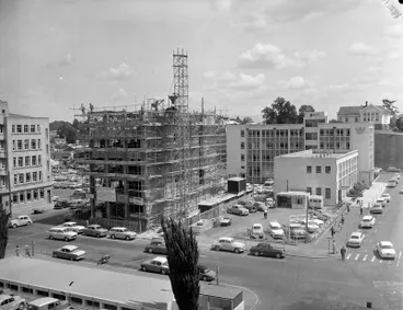
c.1962: Facing Garden Place: Municipal Offices with Wrightson Stephenson's used car sales in front & T.&G. being built
Construction of the T and G building
Hamilton City Libraries
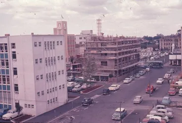
Dec 1962: View of T. & G. being built on corner of Caro & Alexandra Sts with Garden Place at top right
Slide - T. & G. building, corner Caro and Alexandra Streets, Hamilton
Waikato Museum Te Whare Taonga o Waikato
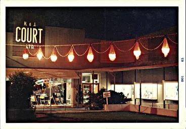
Dec 1963: Garden Place entrance to H. & J. Court Ltd
Garden Place entry to H. & J. Court Ltd. at night
Hamilton City Libraries
Two one-way roads on perimeter of Garden Place for access to businesses
Two one-way roads on the perimeter of Garden Place continued to be used for access to the carpark and businesses located on either side of Garden Place between Victoria Street and Alexandra Street. Vehicles could enter the one-way road from the left side of Victoria St and exit directly ahead onto Alexander St. Similarly, vehicles could enter off the left side of Alexandra St and exit directly ahead onto Victoria St.

May 1964: Aerial photograph showing Garden Place's carpark & public buildings
Hamilton, city centre, showing Garden Place, as 'Parking Meter Place', also public buildings
Alexander Turnbull Library
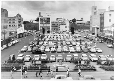
1963: View of Garden Place carpark & the two parallel one-way roads between Victoria & Alexandra Streets
Garden Place - GPO, Buses Ltd, Library
Hamilton City Libraries
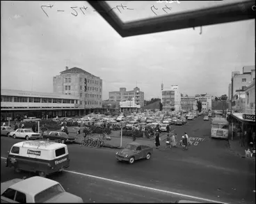
1964: View of Garden Place's road on right off Alexandra St with 'No entry' sign painted at exit on Victoria St
Garden Place
Hamilton City Libraries
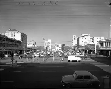
1966: View of Garden Place buildings & cars entering one-way road on left off Victoria St with an exit on Alexandra St
Garden Place from Victoria Street
Hamilton City Libraries
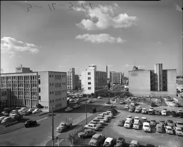
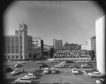
1966: Looking towards Alexandra St and Victoria St, with cars parked on both sides of the men's underground toilets
Garden Place 1966
Hamilton City Libraries
14. Carparks replaced with grassed public space & one-way ring road, 1967
Carparks between Alexandra & Victoria St removed
The Garden Place carparks between Alexandra Street and Victoria Street were removed during 1967 to create a public space encircled by a one-way ring road where vehicles travelled clockwise.
The concrete carparking area was replaced with paved and grassed areas.
Carparking was retained on the far side of Garden Place on the other side of Alexandra Street and Worley Street by the Municipal Offices.

April 1967: Aerial photograph of Garden Place (middle lef) & nearby buildings
Hamilton, including city buildings and Lake Rotoroa
Alexander Turnbull Library
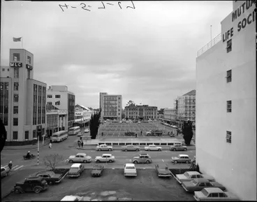
July 1967: Garden Place carparks between Alexandra & Victoria Sts. to be removed. (See trucks on far side of toilets)
Garden Place in 1967 as seen from the Municipal Offices
Hamilton City Libraries
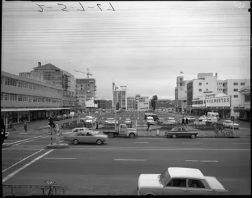
The carparks on other side of Alexandra St in front of Muncipal Offices to be kept. (See view of area from Alexandra St)
Garden Place July 1967
Hamilton City Libraries

View from Anglesea St across to Garden Place & Victoria St showing half of carparks removed
Garden Place July 1967
Hamilton City Libraries
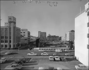
Workers can be seen preparing the ground for planting grass & laying pavements on far side of row of toilets
Garden Place
Hamilton City Libraries

The carparks were replaced with a paved & grassed public space with a one-way ring road clockwise around perimeter
Garden Place aerial 1967
Hamilton City Libraries
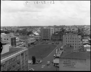
Ring road had a one-way entry off left side of Alexandra St & off left side of Victoria St with exits on opposte sides
Garden Place
Hamilton City Libraries
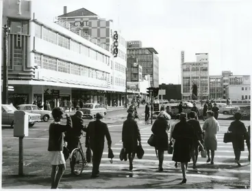
Cars seen entering one-way ring road from Victoria St & exiting onto Alexandra St or travelling around the ring road
Waikato Coverage
Archives New Zealand Te Rua Mahara o te Kāwanatanga
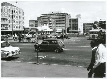
Bus seen on right about to exit the one-way ring road onto Victoria St. A 'No Entry' sign is painted on road.
Auckland Province - Hamilton
Archives New Zealand Te Rua Mahara o te Kāwanatanga
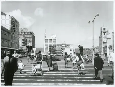
Dec 1968: A view of the pedestrian crossing across Victoria Street to Garden Place
Auckland Province - Hamilton
Archives New Zealand Te Rua Mahara o te Kāwanatanga
Sundial relocated c.20 metres inside Garden Place, 1968

In 1968, the sundial by Victoria St was relocated c.20 metres inside Garden Place nearer the grassed area
Garden Place, Hamilton
Archives New Zealand Te Rua Mahara o te Kāwanatanga

Dec 1968: View of Garden Place with seating near the sundial & new automatic Telephone Exchange Building in the centre
Garden Place, Hamilton, with the new automatic Telephone Exchange Building in the centre of the picture.
Archives New Zealand Te Rua Mahara o te Kāwanatanga
On Anglesea slope, Hamilton Technical College became Waikato Technical Institute, 1968
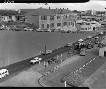
In 1968, on the nearby Anglesea St slope, the Hamilton Technical College became Waikato Technical Institute
Waikato Technical Institute
Hamilton City Libraries
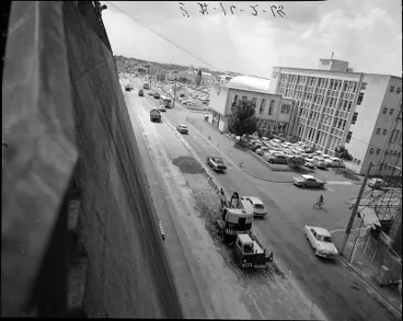
1968: Looking north along wall on Anglesea St. The Municipal Offices are to the right near Caro St.
Anglesea Street
Hamilton City Libraries
Hamilton Public Library moved to William Paul Hall, 1968
During 1968, the Library relocated from the Municipal Offices into the bottom floor of the William Paul Hall, the former Winter Show building on Alexandra St (then known as Barton Street and nowadays Worley Place). The top floor was occupied by the Waikato Museum since 1965. To provide extra space for the Library a mezzanine floor was added during the early 1970s. Later in 1974, the Library also took over the top floor when the Museum relocated to London Street after combining with Hamilton's Art Gallery. The Museum eventually moved to its own purpose-built building on Grantham Street in 1987.
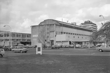
In 1968, Public Library moved to William Paul Hall (built 1956) which had Waikato Museum on top floor from 1965-1974
The Hamilton Public Library in the William Paul Hall
Hamilton City Libraries
15. Garden Place redesigned - pool with fountains, gardens & grassed areas, 1970s -
Fountain City
As a centre-piece of Garden Place, a water fountain and shallow, tiled pool were designed by architects Aubrey and Mary de Lisle in 1967.
During 1968-1970, the remodelling of Garden Place was carried out with the pool and fountain positioned within the gardens and grassed areas.
The fountain along with two others - Dame Hilda Ross Memorial Fountain (1963) at the Founders' Theatre and the Centennial Fountain (1978) in Boyes Park - led to Hamilton being given the title of "Fountain City".

Jan 1971: View of Garden Place's new pool & fountain & its gardens & grassed areas with the ring road on the perimeter
Garden Place
Hamilton City Libraries

1970s: Garden Place pool with fountains & sundial at bottom right
Garden Place fountains in the 1970s
Hamilton City Libraries

Fountains in Garden Place, Hamilton
Archives New Zealand Te Rua Mahara o te Kāwanatanga
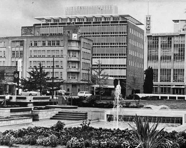
Garden Place fountains
Hamilton City Libraries

1970s: View of Garden Place fountain & Norwich Union Insurance Societies building
Photograph - Garden Place, Hamilton
Waikato Museum Te Whare Taonga o Waikato

c.1970: View of a busy Garden Place looking west from Victoria Street
Garden Place, Hamilton
Hamilton City Libraries

The original Garden Place fountains
Hamilton City Libraries
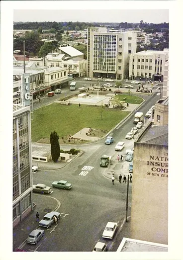
c.1970: Garden Place as seen from a high floor of the Post and Telegraph office building on Caro Street
Garden Place c. 1970
Hamilton City Libraries
Views of grassed areas, gardens & buildings, 1970s
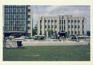
c.1970: Garden Place pool with fountains sited near grassed area
Garden Place c. 1970
Hamilton City Libraries
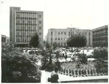
1972: Garden Place looking towards Victoria Street
Auckland - Hamilton
Archives New Zealand Te Rua Mahara o te Kāwanatanga

1970s: BNZ is at the left with the Post Office in centre & ANZ on right
Hamilton Chief Post Office and Bank of New Zealand
Hamilton City Libraries
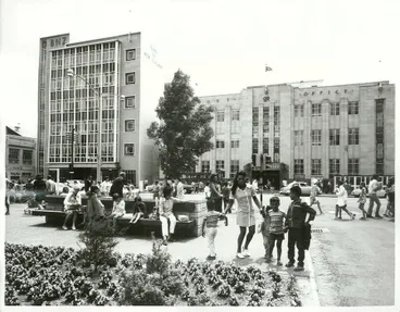
1972: Garden Place with the Post Office across Victoria Street
Auckland - Hamilton
Archives New Zealand Te Rua Mahara o te Kāwanatanga

1970s: Garden Place with another view of the Post Office
Hamilton Central Post Office and Garden Place
Waikato Museum Te Whare Taonga o Waikato
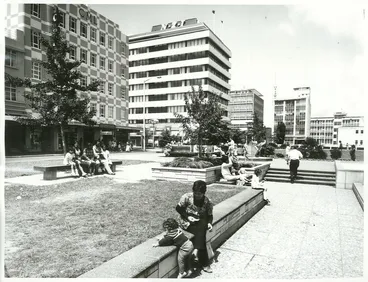
1972: People relaxing in Garden Place near Victoria Street
Auckland - Hamilton
Archives New Zealand Te Rua Mahara o te Kāwanatanga
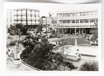
1970s: View of Garden Place & Victoria St, & Norwich Union Insurance Societies Building on corner of Garden Place
Photograph - Garden Place, Hamilton
Waikato Museum Te Whare Taonga o Waikato
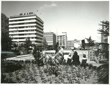
1972: Garden Place looking towards fountains
Auckland - Hamilton
Archives New Zealand Te Rua Mahara o te Kāwanatanga
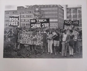
c.1973: Protesters in Garden Place (possibly in connection with the 1973 South African Springbok tour to NZ)
Protest in Garden Place, Hamilton
Waikato Museum Te Whare Taonga o Waikato
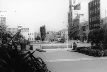
View of Garden Place looking towards Waikato Technical Institute on the hill overlooking Anglesea St
Garden Place
Hamilton City Libraries
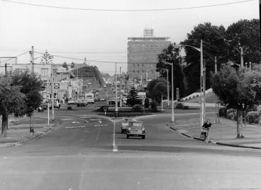
1974: View along Anglesea St to Wintec on hill on the left where cutting made & hill levelled to right for Garden Place
Anglesea Street
Hamilton City Libraries
16. Garden Place closed to traffic from August 1974 - 2011
Garden Place was closed to traffic in August 1974 to create a public space - the 'town square'. The ring road around the perimeter had bollards installed to prevent vehicles entering. The lawns, ornamental plants, fountains and seating had become features of Garden Place to encourage people to spend more time in the inner city.

In August 1974, Garden Place was closed to traffic to create a public space - the 'town square'
Garden Place in the 1970s
Hamilton City Libraries

Bollards were installed on former ring road on left & right. (1970s: South-westerly view of Garden Place from BNZ)
Garden Place, Hamilton
Hamilton City Libraries

1976: A corner of Garden Place near Alexandra Street (now Worley Place) with bollards at both ends
Garden Place
Hamilton City Libraries
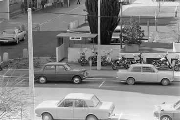
Sept 1976: Bollards to the left of the gentlemen's underground toilets at the end of Garden Place at Alexandra St
Entrance to Garden Place's underground men's toilets
Hamilton City Libraries


1979. Seating near the sundial which had been moved 20m back from Victoria St in 1968
Sundial in Garden Place 1979
Hamilton City Libraries
Buildings continued to surround the perimeter of Garden Place

1976: Looking across Garden Place to the BNZ on Victoria St with pedestrians walking where vehicles used to be driven
Bank of New Zealand and Garden Place
Hamilton City Libraries

1976: Looking across Garden Place to the Post Office (now SkyCity Hamilton since 2002) on Victoria St
Garden Place and the Chief Post Office
Hamilton City Libraries
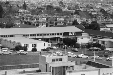
Sept 1976: View of nearby Anglesea St slope & Waikato Technical Institute & its new building being constructed
Waikato Technical Institute (WTI)
Hamilton City Libraries
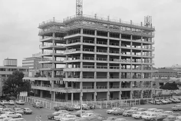
In 1977, construction of Government Life building began at end of Alexandra St on Ward St & opened on 20 Feb 1981
The Government Life building under construction
Hamilton City Libraries
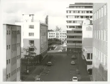
1979: Looking into Garden Place from Caro Street with TIG on top left corner of Caro St & Alexandra Sts
Auckland Province - Hamilton
Archives New Zealand Te Rua Mahara o te Kāwanatanga

Sept 1979: Garden Place shopping included fruit barrow on former carpark area
Garden Place Fruit Barrow, Hamilton
Archives New Zealand Te Rua Mahara o te Kāwanatanga

1979: Nightime: D.I.C. Department Store with access from Garden Place
D.I.C. Shop, Garden Place, Hamilton
Archives New Zealand Te Rua Mahara o te Kāwanatanga
Carparking continued on the other side of Garden Place

1976: Carparking continued on other side of Garden Place by side wing of Municipal Offices & the T&G building on left
Hamilton City Council's Municipal Offices
Hamilton City Libraries
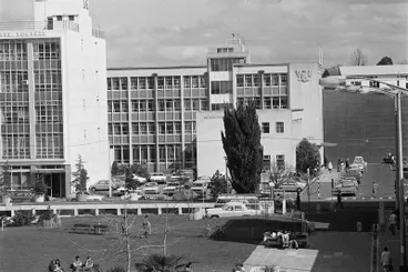
Sept 1976: View of Garden Place's grassed area & seats & the carpark across Alexandra St by T&G & Municipal Offices
Hamilton City Council's Municipal offices
Hamilton City Libraries
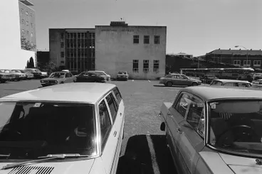
Closer view from Alexandra St of carpark by side wing of Municipal Offices with entrance off Worley St
Hamilton City Council Municipal offices
Hamilton City Libraries
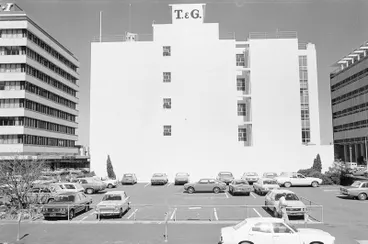
1970s: Closer view from Worley St of carpark by T&G, with NZI (on left) on the corner of Garden Place by Alexandra St
The T & G Building
Hamilton City Libraries
Carpark was extended towards Ward St
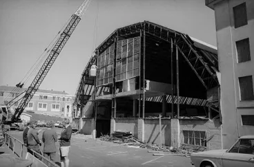
During 1976, to create a large parking area between Worley St & Ward St, Bledisloe Hall was removed to Mystery Creek
The removal of Bledisloe Hall
Hamilton City Libraries
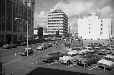
View of the extra parking by Worley St with access from Ward St
Alexandra Street at junction of Worley Street
Hamilton City Libraries
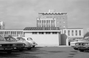
July 1977: View of carpark & public restrooms on corner of Ward St & Anglesea St.
Hamilton City Council's Municipal Offices
Hamilton City Libraries
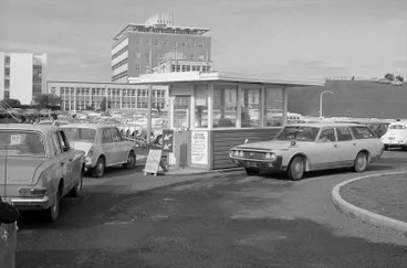
View of carpark's access from Ward St. (Municipal Offices visible on other side of Worley St & tall Telephone Exchange)
Central Car Park
Hamilton City Libraries
Views of Garden Place during 1980s - 1990s

Dec 1985: Overlooking Garden Place
Overlooking Garden Place, Hamilton
Archives New Zealand Te Rua Mahara o te Kāwanatanga

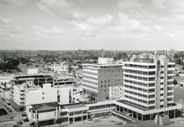
In 1986, the Municipal Offices expanded into part of the carpark with its new Council chambers & tower block wings
Hamilton City Council municipal building
Hamilton City Libraries


1991: A woman sings and plays guitar under shop awnings on the north side of Garden Place
A woman busking in Garden Place
Hamilton City Libraries

1990s: The Gelato Arlecchino and Pizzeria was in Garden Place from 1981 until March 2003
Joe Di Maio's Gelato Arlecchino and Pizzeria in Garden Place
Hamilton City Libraries
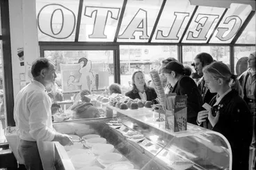
1990s: Interior of Gelato Arlecchino and Pizzeria looking out to Garden Place
Joe Di Maio's Gelato Arlecchino and Pizzeria in Garden Place
Hamilton City Libraries

On 23 March 1993, Hamilton Central Library opened in the former Arthur Barnett/DIC building at Garden Place
HCC_11.jpg
Aotearoa People's Network Kaharoa
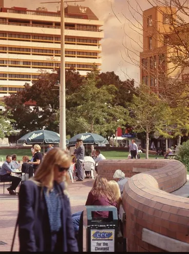
17. Garden Place remodelled 2000 onwards
Garden Place has been through various redesigns to provide spaces to attract pedestrians.
Pool with fountains replaced with paving; & 'pop up' fountain jets added
During the 2000s, Garden Place's pool and fountains were removed and the area paved over. Movable flower boxes were also set up and further sitting areas established.
During the 2010s, a “pop up” fountain type water feature that sprays jets of water between paving stones was installed near the grassed area in front of the Public Library (known as Hamilton City's Central Library - Te Koopuu Maania o Kirikiriroa).
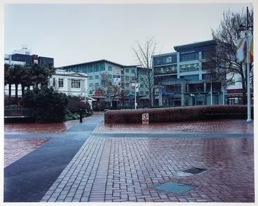
During 200Os, Garden Place's pool was removed & paving stones, movable flower boxes & seating areas set up
Garden Place, Hamilton, 09.08.2003, 7.16
Auckland Art Gallery Toi o Tāmaki
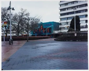
The concrete pool was replaced with paved areas
Garden Place, Hamilton, 02.08.2003, 7.19
Auckland Art Gallery Toi o Tāmaki
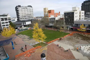
During 2010s, paved area was prepared for small pop-up floor fountains that shoot water upwards from between the paving
Garden Place - 2010-2011
Hamilton City Libraries
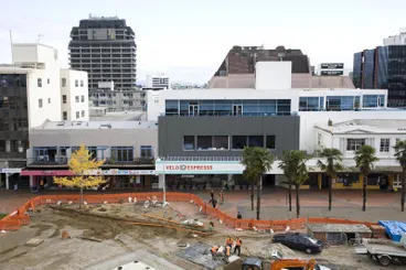
Another view of the paved area where ground-level water jet fountains to be installed in front of the Public Library
Garden Place - 2010-2011
Hamilton City Libraries
Matariki sculpture (2011-2025)
A sculpture by Neil Miller symbolising Matariki was unveiled on 25 Nov 2011. Its design represents Pleiades in the form of a growing vine, with the stars of Matariki forming the fruit on the vine. (See: Stuff (5 May 2011) "'Surprise' sculpture revealed".) Following the redevelopment of Garden Place during mid-2025, the Matariki sculpture was relocated in July 2025 to the Hamilton Gardens and sited near the entrance to the carpark inside Gate 1 off Hungerford Crescent.

Sculpture celebrating concept of Pleiades/Matariki was unveiled 25 Nov 2011 & relocated in July 2025 to Hamilton Gardens
Hawkey, Allan Charles, 1941- : Coming soon to Garden Place ... 6 May 2011
Alexander Turnbull Library

Pleiades was represented as a growing vine with the stars of Pleiades forming the fruit on the vine
"Te Tiaho O Matariki"
New Zealand Outdoor Art
New road between Worley Place & Alexandra St opened 6 June 2012
Garden Place had another makeover to attract foot traffic. A "shared zone" for pedestrians and vehicles near the Council building that connects Worley Place with Alexandra Street was opened on 6 June 2012. (The Base commercial and retail centre had opened in Te Rapa by Tainui Group Holdings in 2005-2006, which was having an impact on the inner city.)

In 2008, planners were considering allowing traffic into Garden Place
'Vehicle traffic through Hamilton's Garden Place could liven up the city centre - Urban Planner'. "I'm heading for Garden Place to liven up the ped...
Alexander Turnbull Library

In Aug 2010, plans were signed off by councillors & a road connecting Worley Place & Alexandra St opened 6 June 2012
"I might change my name to 'Garden Place' - so I can keep on getting expensive makeovers." 27 August 2010
Alexander Turnbull Library
Statues
Captain John Hamilton (2013 - 2020)
In 2013, a bronze statue of Captain John Fane Charles Hamilton, whom Hamilton Cty is named after, was created by Margriet Windhausen as a gift by the Gallagher Group. John Hamilton was a British navy officer who led a regiment fighting against Māori and was killed during the Battle of Gate Pā. The statue became a point of contention for local iwi and other community members. In 2018 it was defaced with red paint and attacked with a hammer. Following a request from Waikato-Tainui, the Council removed the statue on 12 June 2020.

In 2013, statue was erected of Capt John Hamilton (British navy officer at Battle of Gate Pā) whom City is named after
Captain John Fane Charles Hamilton
Hamilton City Libraries
The statue was sited at north end of Garden Place in Civic Square & was defaced with red paint & a hammer in 2013
Captain John Charles Fane Hamilton statue defaces
Radio New Zealand

On 12 June 2020, Hamilton City Council removed Hamilton's statue following a formal request from Waikato - Tainui
Waikato-Tainui welcome removal of Hamilton statue
Radio New Zealand
RNZ article (12 June 2020) & video of the statue's removal which raised debate over artefacts of British colonialism
Hamilton statue's removal raises debate over artefacts of British colonialism
Radio New Zealand
Dame Hilda Ross (2020 - )
On 31 October 2020, a bronze statue of Dame Hilda Ross was unveiled. It was created by Matt Gauldie for the Theatre of the Impossible Charitable Trust (TOTI) Trust. Dame Ross was a Hamilton City councillor, Deputy Mayor, and an MP. She held various posts in the first National government, including member of the Executive Council, Minister of Social Security, Minister of Welfare of Women and Children and Minister of Child Welfare. [See video and article on the unveiling at Stuff.co.nz (31 Oct 2020): Mike Mather. "Battle not over yet for champion of women, children, and poverty-stricken"]
On 31 October 2020, a bronze statue of Dame Hilda Ross (1883-1959) was unveiled at Garden Place
'Hands-on activist': Statue of Hilda Ross being unveiled in Hamilton
Radio New Zealand
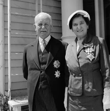
Dame Hilda Ross was a Hamilton Councillor (1944-45), Deputy Mayor (1945), & MP (1945-59) & awarded DBE in 1956
The Governor-General, Sir Willoughby Norrie, and Dame Hilda Ross
Alexander Turnbull Library
Mural (2020)
Since January 2020, a large-scale mural by the Te Whetū Collective adorns the retaining wall along the Anglesea cutting, atop of which is sited Wintec. The mural tells the story of the Hill - it depicts the Waikato River, three tui, and a female portrait representing Mātariki. See film of the mural on Te Ao Maori News (23 Jan 2020): Te Kōpū Mānia o Kirikiriroa mural revitalising local history.
Since Jan 2020, a mural on the retaining wall of the Anglesea cutting tells the story of the history of the Hill
Hamilton artists bring dull wall to life with mural featuring Waikato River, tūī
Radio New Zealand
Gatherings - social, cultural & political events
Garden Place has continued to be used for social, cultural and political events. Next to a small grassed area near Victoria Steet, there is also a raised concrete/stage area three steps high above the paving stones which is also used for live music, cultural performances, community events, and public speakers. To browse past and upcoming events, see listings on the Eventfinda Garden Place Venue Page.


Poster advertising doggy themed activities in Garden Place, Dec 2014
Doggy Day
Hamilton City Libraries
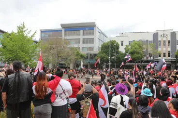
Hikoi against Treaty Principles Bill, 2024
Hikoi against Treaty Principles Bill, Garden Place, Hamilton
Waikato Museum Te Whare Taonga o Waikato
18. Ongoing changes to Garden Place: 2025 -
The Hamilton City Council stated on its website under Garden Place changes(updated 17 June 2025): "We’re making some tangible changes to help Garden Place be a safe space where people want to be".
Programmes included:
Putting the garden back into Garden Place: "Starting 16 June 2025, construction will begin to revamp the gravel area of Garden Place into a nature play garden. Work is expected to take three weeks. The garden will include new plants, stepping stones and balance beams to create a family-friendly area." Consequently, the Matariki sculpture was relocated in July 2025 to the Hamilton Gardens and sited near the entrance to the carpark inside Gate 1 off Hungerford Crescent. See: Isabella Root (2 Sept 2025), "$28k to re-home Garden Place artwork", Waikato Times.
Lighting upgrades: "We’re in the early stages of planning our lighting upgrade for Garden Place which will happen in the 2025/26 financial year."
Central Library facade: "In August 2025, a six-month project to replace the leaking facade of the Central Library will begin." For a photo of the Library's former facade which had a painted mural, see: Hamilton City Library's webpage: History of Hamilton City Libraries. A progress report on 15 April 2026 stated "Central library facade replacement complete"
Bylaw reviews: "Later this year we will be asking for your feedback on a series of bylaws that help to set expectations around behaviour, and outline how people can use Garden Place." Garden Place was attracting "anti-social behaviour" - Sleeping, showering in the water fountains etc
-
Progress reports are provided on the Hamilton City Council's website under News.
>>>>>>>>>>>>>>>>>>>>>>>>>>>>>>>>>
Sources
Hamilton City Council (21 June 2022): Hamilton City Historic Heritage Area Assessment: Appendix 9
Hamilton City Council (2003): “Nga Tapuwae O Hotumauea” Maori landmarks on riverside reserves: Management Plan" (pdf)
Hamilton City Libraries: Heritage Collection Online
Stuff.co.nz (10 Dec 2013): Elton Smallman, "Go back to your marae, that's what it's for": https://www.stuff.co.nz/waikato-times/9496147/Go-back-to-your-marae-thats-what-its-for
Stuff.co.nz (31 Oct 2020): Mike Mather, "Battle not over yet for champion of women, children, and poverty-stricken: https://www.stuff.co.nz/national/123261081/battle-not-over-yet-for-champion-of-women-children-and-povertystricken
Te Ao Maori News (23 Jan 2020): Te Kōpū Mānia o Kirikiriroa mural revitalising local history: https://www.teaonews.co.nz/2020/01/23/te-kopu-mania-o-kirikiriroa-mural-revitalising-local-history/
Wintec: A history of the land on which our city campus sits: https://wintecprodpublicwebsite.blob.core.windows.net/sitefinity-storage/docs/default-source/about-wintec-documents/history-of-wintec-land.pdf?sfvrsn=a5f1ec33_4
This DigitalNZ story was updated in August 2026